Observation: Catherine's Pass

Observation Date
11/28/2019
Observer Name
Gagne/Frey
Region
Salt Lake » Little Cottonwood Canyon » Catherine's Pass
Location Name or Route
Catherine's Pass Area
Weather
Sky
Obscured
Precipitation
Light Snowfall
Wind Direction
West
Wind Speed
Moderate
Weather Comments
Winds switched from south/southeast to the west early in the morning, along with dropping temperatures. Winds were generally light, with occasional moderate gusts.
Snow Characteristics
New Snow Depth
12"
New Snow Density
Medium
Snow Surface Conditions
Powder
Snow Characteristics Comments
Dense snow was inverted making for challenging riding and trail-breaking conditions. HS is generally a meter (40") on sheltered northerly aspects > 9500'. Am finding 60 cms (2') HS on solar (west/south/east) aspects, slopes which were essentially bare a week ago. This is a good sign as it will hopefully providing riding options on slopes other than northerly.
Red Flags
Red Flags
Recent Avalanches
Heavy Snowfall
Wind Loading
Cracking
Collapsing
Poor Snowpack Structure
Avalanche Problem #1
Problem
Persistent Weak Layer
Trend
Increasing Danger
Problem #1 Comments
We've added nearly 2" of water to the snowpack, overloading the fragile layer of weak faceted snow down near the ground. With more snow and wind in the forecast, we can expect to see continued avalanche activity on this layer.
Avalanche Problem #2
Problem
Wind Drifted Snow
Trend
Increasing Danger
Problem #2 Comments
Wind drifts were sensitive on Wednesday and continued wind-loading today and Friday will create additional wind drifts.
Comments
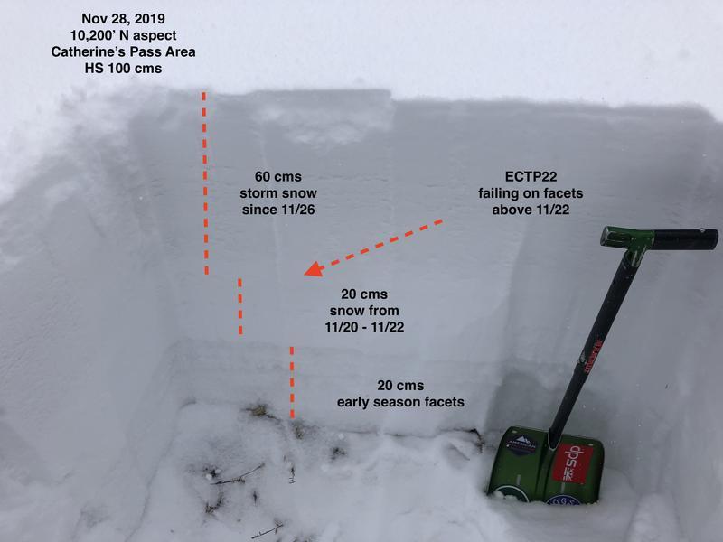
Given the poor snowpack structure on northerly aspects, I was expecting to see more in-you-face instability (avalanches, lots of collapsing and cracking). But we only got a few collapses (although one very loud one!) and some cracking in the storm snow on steep aspects. Did not see any evidence of recent avalanches, but the overnight snow likely covered up any slopes that slid. (i.e. I could not find any evidence of the Wednesday slide in Rocky Point.)
Photo below highlights poor snowpack structure.
Generally poor visibility today, but was able to travel a bit on some south and west aspects and am finding better coverage with dense snow. With more dense snow in the forecast, this will help fill in these aspects and provide us options other than northerly aspects.
Today's Observed Danger Rating
High
Tomorrows Estimated Danger Rating
High