icon-add
Observation
Menu
×
Menu
Forecasts
Logan
Ogden
Salt Lake
Provo
Uintas
Skyline
Moab
Abajos
Weather
Archives
How to read the forecast
Observations & Avalanches
Submit Observation
Observations Explorer
All Observations
Avalanches
Fatalities
Weather
Place Names Map
Archives
Education
Avalanche Class List
UAC Class List
Online Classes
Resources and Tutorials
Avalanche Awareness
Develop Skills
Events
Store
About
Contact
Who we are
Core Values
Staff
Board of Directors
Past Forecasters
Sponsors
Annual Reports
Sign In
Blog
Donate / Join
Search
Forecasts
Logan
Ogden
Salt Lake
Provo
Uintas
Skyline
Moab
Abajos
Weather
Archives
How to read the forecast
Observations & Avalanches
Submit Observation
Observations Explorer
All Observations
Avalanches
Fatalities
Weather
Place Names Map
Archives
Education
Avalanche Class List
UAC Class List
Online Classes
Resources and Tutorials
Avalanche Awareness
Develop Skills
Events
Store
About
Contact
Who we are
Core Values
Staff
Board of Directors
Past Forecasters
Sponsors
Annual Reports
Sign In
Blog
Menu
Search
icon-add
Observation
Donate / Join
Submit Observation
Observations Explorer
All Observations
Avalanches
Fatalities
Weather
Place Names Map
Archives
Submit Observation
Observations Explorer
All Observations
Avalanches
Fatalities
Weather
Place Names Map
Archives
Observation: White Pine
Observation Date
3/25/2019
Observer Name
T Diegel
Region
Salt Lake » Little Cottonwood Canyon » White Pine
Location Name or Route
white pine
Weather
Sky
Clear
Wind Direction
Southwest
Wind Speed
Moderate
Weather Comments
A bit cooler and a bit more breezy than I anticipated from the forecast. On high ridges my skin track was filled back in within an hour.
Snow Characteristics
New Snow Depth
8"
New Snow Density
Low
Snow Surface Conditions
Powder
Snow Characteristics Comments
On the bed surfaces - and there were many - the snow was hard and smooth with an inch or two on top; quite edgeable.
Red Flags
Red Flags
Recent Avalanches
Rapid Warming
Red Flags Comments
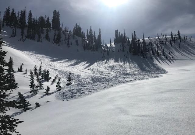
As advertised, there were a ton of small-to-medium sized avalanches yesterday on 35+ degree slopes (see pic for one reference); most natural, a few looked skier-triggered. I was only on E facing yesterday and got wettish slides, but clearly there was not a good bond on north facing either, at least for the high PI that burst out yesterday. But as Drew mentioned this morning, this stuff seemed to tighten up fast, with me and others able to ski relatively steep north facing lines without a problem. Some very minor sluffing in some steep trees, but in the more exposed areas there wasn't much. I watched a smallish natural wet slide come off of the E face of the Rocky Nob below No Name late morning (see pic) and kind of anticipated seeing that pick up as the day went on, but there was less of that than anticipated, even on the big S. facing lines across the valley (I was hoping that LCC wasn't going to have an afternoon closure). But maybe if it is a few degrees warmer on Tue that new snow might come unglued?
Today's Observed Danger Rating
Moderate
Tomorrows Estimated Danger Rating
Considerable