


Observation Date
3/25/2019
Observer Name
Derek DeBruin
Region
Ogden » Ben Lomond
Location Name or Route
Ben Lomond SW Buttress & Ridge
Comments
Woke up in the darkness this morning to tickle the toes of the beast (i.e. the south face of Ben Lomond). My philosophy is that you certainly won't ski anything if you stay home, and if you go, you might just get lucky with conditions (as long as you're willing to turn around if conditions dictate). So, we rose early to see what was up there. The pulses of weather over the weekend with mobile rain/snow lines, variable precip amounts, and even snow in the valley yesterday left me with lots of questions.
At the lowest elevations, we still found just enough snow for skinning from the valley (though not quite enough for skiing back the whole way given the large number of rocks). Generally damp snow featured a breakable graupel crust a couple inches thick. As we climbed to mid elevations, we hit what appeared to be a mobile rain/snow line between 6500 and 7500 feet, based on the new snow amounts. As noted above, the general theme was dense, wet snow about 12 to 15 inches down with loose snow above and a graupel crust on top. Trail breaking was arduous--punch through crust, fall into powder, slide on wet crusty surface, find footing, repeat. Hand pits and cautious stomps near and along the southwest ridge revealed some cohesion in the surface snow above about 7800 feet that lent itself to making blocks (though no really "cracking"); surface snow was also not terribly well bonded to the old snow, slipping beneath our skis and running a fair distance. Above 7800 feet yesterdays snowfall was a bit better preserved with dense powder turns.
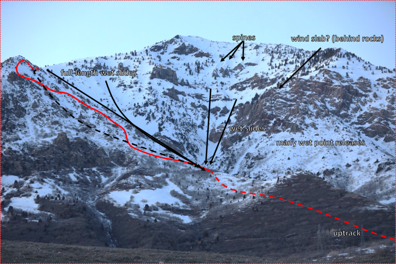
In the photo (about a week old, pre-storm), I've indicated our approximate up track (red line) as well as the location of avalanche activity. The east facing flank of the SW buttress/ridge (looker's left in photo) featured a number of repeater full-length slides into the belly of the beast. The old snow had a thin facet layer in one place I poked around, and also featured the sparkle of surface hoar here and there, leading me to think that the recent new snow, daily heating, firm bed surface with possible facets, and poorly bonding new snow combined to create these slides. The main face featured wet slides from the mid elevations through pretty much every channel into the maw. Pretty much any place rock met sun there were the expected small point releases. Also of note was a large crown in the west facing zone (looker's right, hidden behind the rocks of the SE buttress). From our vantage it was probably a few hundred feet across and maybe one and a half feet deep (unfortunately my only photo of this is all kinds of blurry). This might be owing in part to the "backwards" (easterly) winds we experienced last week loading this zone (not sure if this is the same avalanche detailed here, or perhaps related and increased in size with increased loading from new snow: http://www.ogdenavalanche.org/2019/03/ben-lomond-avalanche-on-march-21-and.html). Finally, while no avalanches had occurred, the spines just looker's right of the summit ramp seemed to be corniced from prevailing easterly wind and appeared to have cross loading in the pockets between.
One final hazard to note: with all of the new water in the last few days, the bottom of the south face drainage from the choke point and lower now features a creek that's running pretty stoutly with 4 to 6 foot tall tumbles into whitewater awaiting the traveler who fails to approach it with caution or anticipate the need to cross it.
In short, we turned around.
Today's Observed Danger Rating
Considerable
Tomorrows Estimated Danger Rating
Considerable
Coordinates