icon-add
Observation
Menu
×
Menu
Forecasts
Logan
Ogden
Salt Lake
Provo
Uintas
Skyline
Moab
Abajos
Weather
Archives
How to read the forecast
Observations & Avalanches
Submit Observation
Observations Explorer
All Observations
Avalanches
Fatalities
Weather
Place Names Map
Archives
Education
Avalanche Class List
UAC Class List
Online Classes
Resources and Tutorials
Avalanche Awareness
Develop Skills
Events
Store
About
Contact
Who we are
Core Values
Staff
Board of Directors
Past Forecasters
Sponsors
Annual Reports
Sign In
Blog
Donate / Join
Search
Forecasts
Logan
Ogden
Salt Lake
Provo
Uintas
Skyline
Moab
Abajos
Weather
Archives
How to read the forecast
Observations & Avalanches
Submit Observation
Observations Explorer
All Observations
Avalanches
Fatalities
Weather
Place Names Map
Archives
Education
Avalanche Class List
UAC Class List
Online Classes
Resources and Tutorials
Avalanche Awareness
Develop Skills
Events
Store
About
Contact
Who we are
Core Values
Staff
Board of Directors
Past Forecasters
Sponsors
Annual Reports
Sign In
Blog
Menu
Search
icon-add
Observation
Donate / Join
Submit Observation
Observations Explorer
All Observations
Avalanches
Fatalities
Weather
Place Names Map
Archives
Submit Observation
Observations Explorer
All Observations
Avalanches
Fatalities
Weather
Place Names Map
Archives
Observation: Salt Lake
Observation Date
3/24/2019
Observer Name
CBrown
Region
Salt Lake
Location Name or Route
Wolverine & Patsy Marley
Weather
Sky
Obscured
Precipitation
Heavy Snowfall
Wind Direction
West
Wind Speed
Light
Weather Comments
High P.I. around noon today. Light winds with gusts maybe reaching moderate. Short periods of sun and greenhousing.
Snow Characteristics
New Snow Depth
10"
New Snow Density
Medium
Snow Surface Conditions
Powder
Melt-Freeze Crust
Damp
Snow Characteristics Comments
Seemed to be about 10" HN. When the sun popped sunny slopes took some heat quickly.
Red Flags
Red Flags
Recent Avalanches
Heavy Snowfall
Wind Loading
Cracking
Rapid Warming
Red Flags Comments
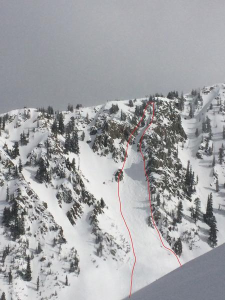
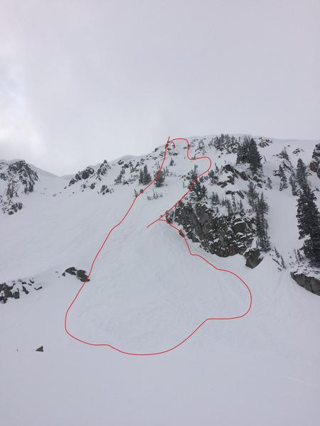
Lots of red flags out there today. Instability peaked with the high PI rates. No natural avalanches observed but plenty of skier triggered from loose dry sluffs to soft storm/wind slab. Triggered and avalanche on the east face of patsy, sluff on the upper steep face with not much new snow left which pulled out a few soft slabs lower down, fairly stubborn, size 1.5 Also triggered an avalanche in one of the W facing couloirs in Wolverine Cirque, Small 12" slab was touchy at the top where there was a NW tilt, suspect FC below the new snow as the bed surface was thin rocky and NNW tilt, this pulled out larger but shallower chunk in the wider portion of the chute, 6", size 1.5. It seemed as though it needed to be >35* to move today. I had lots of cracking and slight movement but wouldn't go anywhere unless it was steeper than 35*.
Avalanche Problem #1
Problem
New Snow
Trend
Decreasing Danger
Problem #1 Comments
Loose dry and storm slab out there of varying sensitivity. Most observed were rather stuborn.
Avalanche Problem #2
Problem
Wet Snow
Trend
Same
Problem #2 Comments
Sun and temps will effect the new snow quickly.
Today's Observed Danger Rating
Moderate
Tomorrows Estimated Danger Rating
Moderate
Coordinates