Forecast for the Uintas Area Mountains

Craig Gordon
Issued by Craig Gordon for
Saturday, March 16, 2019
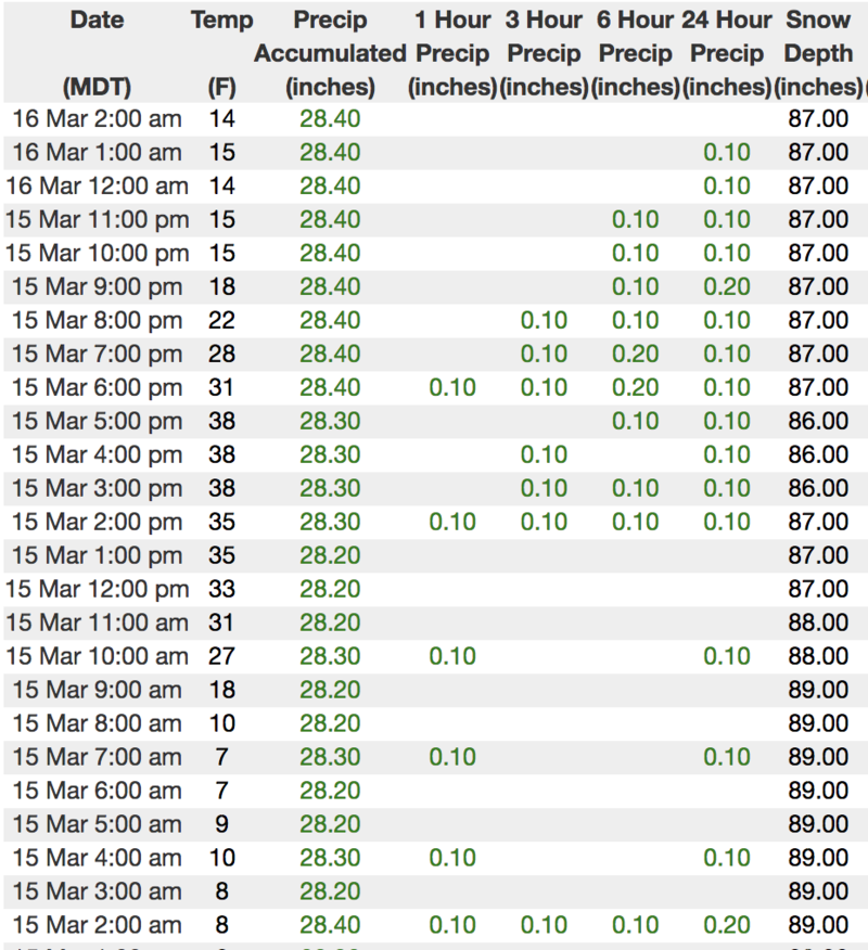
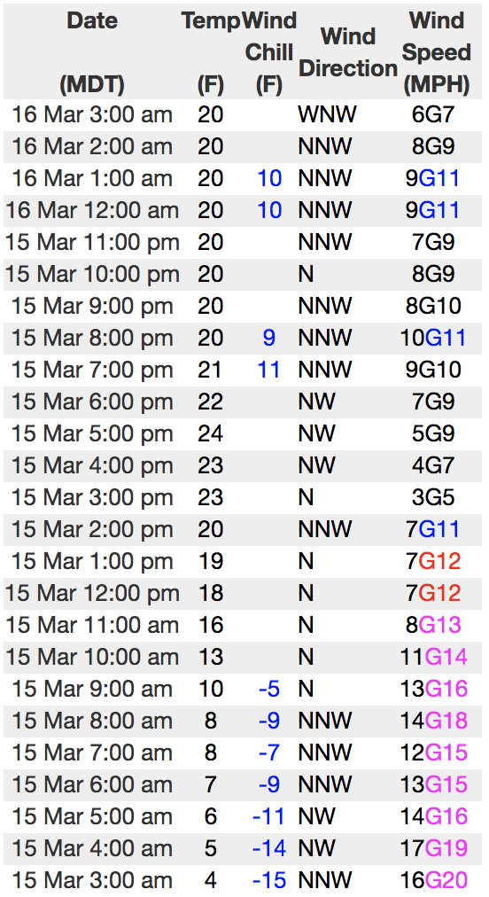
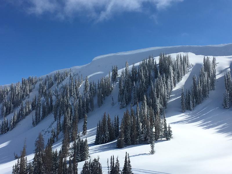
Heads up.... the avalanche danger is more pronounced on the North Slope which received the lion's share of Wednesday's storm
On the south half of the compass-
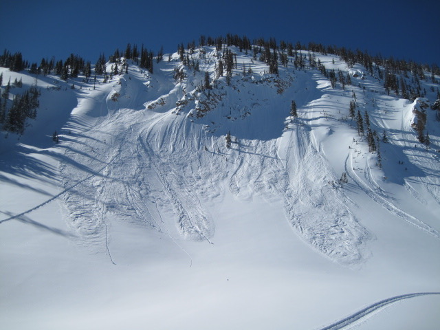
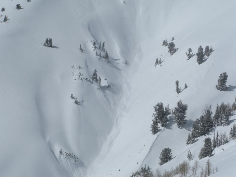
On steep upper elevation slopes the danger of wet avalanches increases to CONSIDERABLE with daytime heating and human triggered avalanches are LIKELY, especially on slopes facing the south half of the compass.
On the north half of the compass-
MODERATE danger for dry snow avalanches exists on steep, shady slopes in the wind zone and human triggered avalanches are POSSIBLE on wind drifted, leeward slopes.
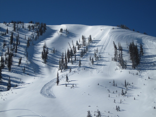
On all quadrants of the compass-
Mid and low elevation terrain start the day with LOW avalanche danger, which rises to MODERATE as temperatures rise. Human triggered avalanches are POSSIBLE on steep sun baked slopes during the heat of the day.
Low
Moderate
Considerable
High
Extreme
Learn how to read the forecast here
Weather and Snow
Skies remained clear last night and warmer air filtered into the region, bumping temperatures into the teens and low 20's overnight. Winds are hardly noticeable, blowing just 10-15 mph along the high ridges. On a go anywhere base and a truly epic midweek storm, riding and turning conditions are about as good as they get. From the North Slope Ted reports..... "Amazing riding and turning conditions today and even I felt like I was getting after it with over the hood conditions. A nice solid two feet of low density snow that rode quite well, a few places the old hard tracks were felt, but riders were stoked to be out on this sunny day."
Above is hourly data from Trial Lake (9,945') and Windy Peak (10,662'). To view more regional weather stations click here.
The south half of the compass took on a bit of heat the past few days and this morning, you'll find sunny slopes slightly crusted. However, simply follow Weston's lead like in the viddy above and switch to terrain facing the north half of the compass and you'll be rewarded with deep, cold, light snow for the slashing :)
Recent Avalanches
Ted was near Moffit Peak yesterday and found the region experienced a widespread, albeit shallow new snow avalanche cycle. More on his travels here.
Recent trip reports and avy activity found HERE.
Ad
Avalanche Problem #1
Wet Snow
Type
Location
Likelihood
Size
Description
The sun is high in the sky and the storm snow will continue to take on heat today. In the top image above you can clearly see how a small avalanche on a south facing slope, starting out as a point release and has no problem entraining snow as it descends the slope. The lower image illustrates the type of terrain you wanna avoid today.... deep gullies and road cuts where cement-like debris has no place to fan out, piling up a surprisingly deep pile of wet, manky, cement-like debris. If you're feeling like an ant under a magnifying glass so is the snow. As the day heats up, simply get off of and out from under steep, sun baked slopes.
And don't forget-
Cornices are ginormous and may break back further than you might expect. You definitely wanna give these large, unpredictable pieces of snow a wide berth and not ruin someones day below by inadvertently knocking a boxcar size piece of snow down on them.
Avalanche Problem #2
Wind Drifted Snow
Type
Location
Likelihood
Size
Description
The image above shows steep upper elevation terrain in Moffit Basin, clearly showing what we're dealing with in the wind zone. A few lingering wind drifts formed earlier in the week lurk under Wednesday nights storm and may react to our additional weight. Limited to steep, leeward terrain in the wind zone and big enough to boss you around, look for and avoid fat, rounded pieces of snow that once triggered, may take you for an unexpected ride in steep, technical terrain.
Additional Information
High pressure strengthens through the weekend, producing mostly sunny skies, light winds and temperatures climbing into the 30's. A midweek storm may have enough punch to reach our area and then a somewhat stronger storm develops next weekend.
General Announcements
The information in this advisory expires 24 hours after the date and time posted, but will be updated by 7:00 AM Sunday March 17th, 2019.
If you're getting out and about, please let me know what you're seeing especially if you see or trigger and avalanche. I can be reached at [email protected] or 801-231-2170
It's also a good time to set up one of our very popular avalanche awareness classes. Reach out to me and I'll make it happen.
This information does not apply to developed ski areas or highways where avalanche control is normally done. This advisory is from the U.S.D.A. Forest Service, which is solely responsible for its content. This advisory describes general avalanche conditions and local variations always occur.