Observation Date
12/29/2018
Observer Name
B
Region
Salt Lake » Big Cottonwood Canyon » Brighton Perimeter
Location Name or Route
Brighton Periphery/Catherines/Tuscarora
Weather
Sky
Obscured
Precipitation
Light Snowfall
Wind Direction
Northwest
Wind Speed
Moderate
Weather Comments
Forecast did not verify as skies were obscured for the morning hours with a brief period of broken and then back to overcast in the afternoon. As well, the forecast for no precipitation
was incorrect as light snow (S-1) was occurring throughout the morning and into the early afternoon with accumulation of 2 cm. Winds were out of the NW and on the high end of Moderate until 1200. They appeared to back down significantly by mid day, yet wind blown and or transport was observed on the highest ridge lines at a moderate level. Temperatures appeared to be at least 15 degrees warmer today.
Snow Characteristics
New Snow Depth
1"
New Snow Density
Low
Snow Surface Conditions
Powder
Wind Crust
Snow Characteristics Comments
Another day of cold weather and lack of enough solar to prevent the southerly aspects from warming and getting a crust. Riding continues to be excellent in sheltered areas with bottomless turning. Wind damage appeared to be increasing at the upper elevations in exposed terrain.
Red Flags
Red Flags
Recent Avalanches
Wind Loading
Poor Snowpack Structure
Red Flags Comments
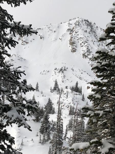
Thin rocky areas still have weak snow and in steep northerly facing terrain this is noticeable. Yet, the majority of the terrain in the upper Cottonwoods appears to be gaining a mid winter type snow pack with the structure improving each day. Wind loading continues to be an issue in the exposed upper elevation terrain with the potential for sensitive newly formed wind slabs an issue; and with the forecast for increasing winds over the next 48 hours this issue may be increasing. See photo of small Loose Dry Avalanche off the SE shoulder of Tuscarora. And, several natural similar sized Loose Dry Avalanches were observed in steep cliff like terrain.
Avalanche Problem #1
Problem
Wind Drifted Snow
Trend
Increasing Danger
Problem #1 Comments
See above regarding the Wind Slab Problem.
Avalanche Problem #2
Problem
New Snow
Trend
Increasing Danger
Problem #2 Comments
Storm Slabs and Loose Dry may become an issue over the next 36 hours with increasing winds and snow in the forecast. See above for recent Loose Dry.
If the winds indeed increase as forecast the percip values exceed the current forecast the danger rating for Sunday may escalate to Considerable by late Sunday afternoon and into the evening hours with Natural avalanches possible.
Today's Observed Danger Rating
Moderate
Tomorrows Estimated Danger Rating
Considerable