Observation Date
11/29/2018
Observer Name
Greg Gagne
Region
Salt Lake » Little Cottonwood Canyon
Location Name or Route
Grizzly -> Wolverine -> Catherine
Weather
Sky
Overcast
Precipitation
Moderate Snowfall
Wind Direction
Southwest
Wind Speed
Strong
Weather Comments
Moderate to strong winds out of the south/southwest drifting onto northerly aspects. Drifts were generally 15-30 cms (6-12") and somewhat sensitive in places. Largest drifts I encountered were right along the ridges and up to 45 cms (18")
Snow Characteristics
New Snow Depth
8"
New Snow Density
Medium
Snow Surface Conditions
Powder
Snow Characteristics Comments
Rimed crystals falling from the sky with generally 4-8" storm snow since Wednesday. Nice dense snow which makes for excellent riding on low-angled slopes.
HS generally a meter in many locations above 9000' in upper LCC and BCC. Range is generally 60-120 cms (2-4') with lower amounts on southerly aspects.
Red Flags
Red Flags
Recent Avalanches
Heavy Snowfall
Wind Loading
Cracking
Collapsing
Poor Snowpack Structure
Red Flags Comments
Cracking and collapsing not as widespread as earlier this week, but still several collapses. ECT's were mostly propagating (scores between mid teens and mid 20's) although some did not propagate.
Avalanche Problem #1
Problem
Persistent Weak Layer
Trend
Increasing Danger
Problem #1 Comments
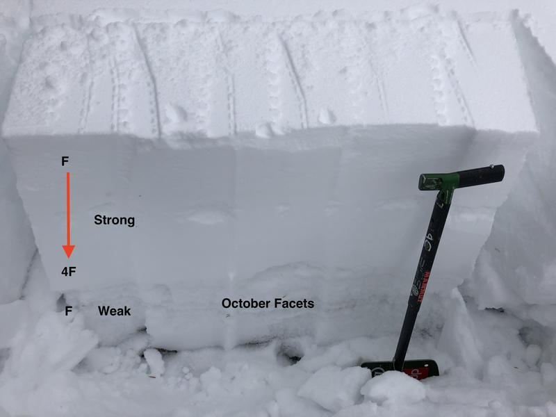
My field day was consistent with other observers have noted this past week - the slab from the Thanksgiving storm is stiffening up a bit and the October facets have adjusted to the load somewhat. Fewer collapses and the cracks were not propagating as widely. But, we've added 0.6-1.0" of water to the snowpack since Wednesday, and moderate to strong southerly winds as well. With more snow and wind in the forecast overnight and into Friday, am expecting the persistent weaknesses now down 30-60 cms (1-2') to become reactive once again.
Avalanche Problem #2
Problem
Wind Drifted Snow
Trend
Increasing Danger
Problem #2 Comments
Wind drifts were somewhat sensitive and generally in the 15-30 cm range (6-12"), although some drifts were up to 45 cms (18"). These drifts will overload persistent weaknesses on northerly facing slopes, further complicating the persistent weak layer problem, but also may be an issue on all aspects at the upper elevations.
Comments
Nearly 1" of water since Wednesday, increasing winds on Thursday, and more snow and wind forecasted overnight Thursday and Friday means a rising avalanche hazard. Fortunately, southerly aspects have been filling in and they should provide excellent alternatives to the northerly slopes this coming weekend.
Photo of typical snowpack structure showing strong-over-weak where the Thanksgiving storm slab is 4F hardness, but it is sitting on top of weak faceted snow from October.
Video of wind-loading from southerly winds onto northerly aspects.
Video
Video illustrating how a small test slope can often tell you all you need to know about conditions!
Video
Today's Observed Danger Rating
Considerable
Tomorrows Estimated Danger Rating
High