Forecast for the Skyline Area Mountains

Brett Kobernik
Issued by Brett Kobernik on
Saturday morning, March 31, 2018

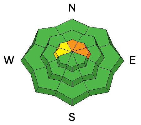
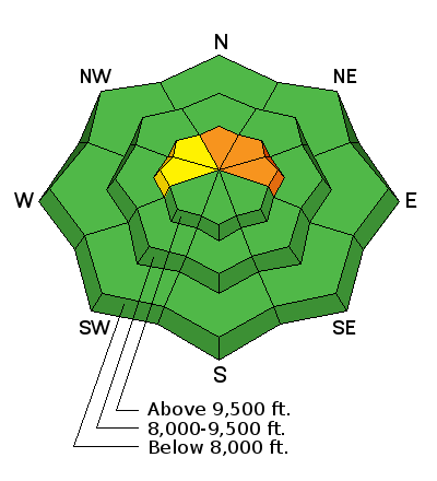
The majority of the terrain along the Skyline has a LOW to MODERATE danger. It is still possible that a person could trigger an avalanche that breaks to the ground in the upper elevation north through east facing slopes approaching 40 degrees in steepness. Chances for triggering an avalanche are low but the consequences are high.

Low
Moderate
Considerable
High
Extreme
Learn how to read the forecast here
Weather and Snow

Wind and sun have taken a toll on the riding conditions but you can still find some soft settled snow around. Overnight temperatures were in the mid 20s and the wind was moderate in speed from the west.

Recent Avalanches

The wind blew the new snow from last Sunday into sensitive drifts during the week. There were a few natural avalanches as well as some small human triggered slides. The human triggered slides were 1 to 2 feet deep on small slopes and involved only the new snow. There was at least one large natural avalanche that I could see in the Little Horseshoe. From a distance using a spotting scope, it appears to be only new snow but this is speculation. At this point the newer drifts from this week are not too sensitive anymore.

Ad
Avalanche Problem #1
Persistent Weak Layer
Type
Location
Likelihood
Size
Description

The most dangerous situation still involves the weak sugary snow near the ground. Snowpit tests continue to show poor results with clean shears and propagation. They are difficult to get to fail at this point. I still don't feel comfortable about getting onto many of my favorite big slopes in the higher northerly terrain. It seems fairly unlikely that a person could trigger something but I've been fooled in the past by buried faceted sugary snow. I just can't trust the stuff.

LINK TO FIELDWORK VIDEO

Additional Information

We'll see some high clouds moving through today with warm temperatures in the low 40s along the ridgetops and moderate speed ridgetop wind from the west. Sunday looks very similar, perhaps a few less clouds. We may see a couple minor weather disturbances during the week that won't bring any significant snow. Weather models are continuing to advertise a larger storm about a week out.

General Announcements

Support the Utah Avalanche Center through your everyday shopping. DETAILS HERE

We will publish full detailed advisories Saturday and Sunday mornings by 7am. We will also be publishing basic avalanche danger ratings & info during the week.

If you are getting out into the mountains, we love to hear from you! You can SUBMIT OBSERVATIONS ONLINE or EMAIL US

If you would like to have avalanche advisories emailed to you, SIGN UP HERE

We can provide basic avalanche awareness presentations for your school, group or club. To enquire, CLICK HERE