Forecast for the Salt Lake Area Mountains

Trent Meisenheimer
Issued by Trent Meisenheimer for
Tuesday, March 27, 2018

The avalanche danger will rise to CONSIDERABLE for wet loose avalanches at the mid and upper elevation steep east through west facing terrain. You'll find an isolated MODERATE danger for deep slabs at upper elevation northwest through east facing terrain. LOW danger elsewhere.

Loose dry avalanches, and shallow wind slabs can be triggered today, especially at the upper elevation northerly facing terrain. Even a small slide is serious if a ride would carry you off a cliff, into trees or down a long, icy slope.

Low
Moderate
Considerable
High
Extreme
Learn how to read the forecast here
Special Announcements

Only 1 more week to support the UAC when you shop at Whole Foods. The Whole Foods Bag Donation ends March 31. When you bring your own bags to Whole Foods in Sugar House, Trolley Square, and Cottonwood Heights you can choose to have the UAC be the recipient of your 10 cent bag credit.

The UAC Marketplace is still open. Our online marketplace still has deals on skis, packs, airbag packs, beacons, snowshoes, soft goods and much more.

Weather and Snow

This morning it's clear, cold and crisp - with current mountain temperatures in the single digits to low teens F°. Winds are from the north and light, averaging 5-10 mph at upper elevations. The last few snowflakes fell yesterday afternoon, leaving behind a fairly uniform 4-8" of new snow in the SLC mountains.

There is a supportable crust beneath the new snow on most all aspects and elevations up to about 10,000'. Upper elevation northerly facing slopes are holding the best of the shallow, cold dry snow. The icy crusts may not soften for the next few days, so be prepared for hard, “slide for life” conditions on many aspects in steep terrain.

Mark White and Drew Hardesty have observations that are worth reading found HERE.

Recent Avalanches

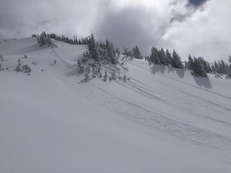
Most all the avalanche activity yesterday was within the new snow. Many loose dry avalanches were reported, these were confined but not limited to steep northerly facing terrain.

Observers were out in the bigger terrain in LCC yesterday and noted large and destructive avalanches that ran naturally sometime around Thursday, March 22nd. They were all class 3 in destructive size, facing north through east and in the elevation range of 10,200-10,500'. These slide were observed in Box Elder, Pheifferhorn, and the Hogum head wall.

Photo: Left - L.Dunn showing a dry loose avalanche. Photo: right - Mark White showing another dry loose avalanche.

Ad
Avalanche Problem #1
Wet Snow
Type
Location
Likelihood
Size
Description

The light, cold, dry snow will see the strong March sun for the first time today ~ with 4-8" of new snow sitting on a very slick and uniform hard layer, the loose wet snow will likely run fast and far - piling up deeply in tight chutes and gulleys. If you are going to be in steep southerly facing terrain, be mindful of whats above and below you. If the snow becomes damp or you start seeing rollerballs shedding off of cliffs or rocks bands, it's time to get out of there.

Avalanche Problem #2
New Snow
Type
Location
Likelihood
Size
Description

Long running sluffs on sustained slopes steeper than 35°, and shallow wind slabs can be triggered today, especially at the upper elevation northerly facing terrain. While these slides would be shallow, the terrain you are in will make a difference. Even a small slide is serious if a ride would carry you off a cliff, into trees or down a long, icy slope.

Avalanche Problem #3
Deep Slab
Type
Location
Likelihood
Size
Description

At upper elevations it is still possible to trigger a deep slab avalanche in very isolated places breaking on a weak facet layer. Slopes with a shallower snow pack are most suspect – including those that have slid one or more times this year or are steep and rocky. It’s a low probability of triggering a slide, but high consequences if you do.

Additional Information

Glorious mountain weather is on tap for today - clear, calm and sunny. Mountain temperatures will top out in the mid 30's at 9,000'. Winds will remain from the north and should be well behaved with speeds in the 5-15 mph range at upper elevations.

General Announcements

CLICK HERE FOR MORE GENERAL INFO AND FAQ

The UAC has new support programs with Outdoor Research and Darn Tough. Support the UAC through your daily shopping. When you shop at Smith's, or online at Outdoor Research, REI, Backcountry.com, Darn Tough, Patagonia, NRS, Amazon, eBay a portion of your purchase will be donated to the FUAC. See our Donate Page for more details on how you can support the UAC when you shop.

Benefit the Utah Avalanche Center when you buy or sell on eBay - set the Utah Avalanche Center as a favorite non-profit in your eBay account here and click on eBay gives when you buy or sell. You can choose to have your seller fees donated to the UAC, which doesn't cost you a penny

This information does not apply to developed ski areas or highways where avalanche control is normally done. This advisory is from the U.S.D.A. Forest Service, which is solely responsible for its content. This advisory describes general avalanche conditions and local variations always occur.