

Forecast for the Skyline Area Mountains

Sunday morning, March 25, 2018
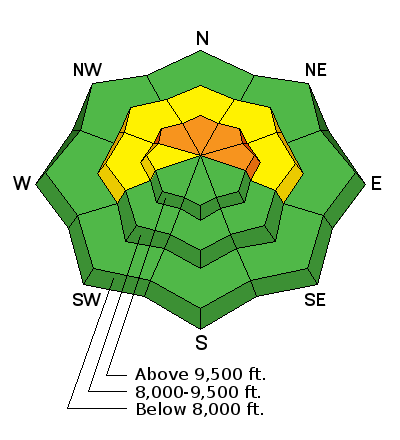
The majority of the terrain along the Skyline has a LOW to MODERATE danger. There is still a chance that a person could trigger a very dangerous avalanche on slopes steeper than 35 degrees that face northwest, north and east above about 9500'. Likelihood of triggering something is low, consequences are high.
 Weather and Snow
A quick hitting storm last night produced 5 to 10" of new snow along the Skyline. The higher amounts are in the central portion of the Skyline around Ephraim Canyon. The top of Fairview Canyon received about 5" and areas farther south near 12 Mile Canyon picked up a little less.
The new snow won't change the avalanche conditions a whole lot. There may be some activity involving the new snow in areas that received the most snow. This alone should be manageable. I would continue to avoid the bigger steep upper elevation northwest through east facing slopes where a person could still trigger something that breaks to the ground.

General Announcements
Support the Utah Avalanche Center through your everyday shopping. DETAILS HERE
We will publish full detailed advisories Saturday and Sunday mornings by 7am. We will also be publishing basic avalanche danger ratings & info during the week.
If you are getting out into the mountains, we love to hear from you! You can SUBMIT OBSERVATIONS ONLINE or EMAIL US
If you would like to have avalanche advisories emailed to you, SIGN UP HERE
We can provide basic avalanche awareness presentations for your school, group or club. To enquire, CLICK HERE