Forecast for the Ogden Area Mountains

Thursday morning, March 22, 2018
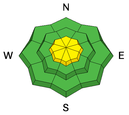
We start out at MODERATE this morning and should be at CONSIDERABLE by late afternoon. Plan for it to go to HIGH danger overnight. Keep an eye on the weather - strong winds, heavy rain and snowfall - all of these lead to a rising avalanche danger on all aspects and elevations. Natural and human triggered avalanches will go from possible to certain within 24 hours. Good luck.

 Special Announcements
POWDER MOUNTAIN RESORT will be closed today due to the expected weather and avalanche conditions.
 Weather and Snow
In the book of Genesis, Noah is instructed to build an ark. You know the story. What used to be called the Pineapple Express and more commonly now referred to as an Atmospheric River is on the doorstep. Skies are overcast and I anticipate off and on rain up to 9500' today. By tomorrrow, the precipitation buckets may have upwards of 1-2" of rain and then snow-water-equivalent. At least the southwest winds will be howling. Gusts may reach 70, 80, 90mph up high. Temperatures are in the upper 30s to low 40s. Even now.
Wet Snow

Description
Forecast rain and then heavy rain up to 9-9500' will result in wet avalanches (sluffs and perhaps slabs) around the compass below the rain/snow line. The more significant wet activity may be expected on the northern end of the compass at the low to mid elevations where the colder, drier snow exists. Natural and human triggered wet avalanches are certain. Expect waterfalls in the mid to low elevation runouts and couloirs. Avoid being in and under steeper soggy terrain, especially in terrain traps such as creekbeds and steep-walled gullies.
Persistent Weak Layer

Description
One to two inches of rain and snow-water-equivalent along with strong winds should be enough to tip the scales for deep slab activity with avalanches stepping down 1-3'+ deep. The most problematic areas will be in steep rocky terrain above 8000' on north to east facing slopes. Terrain adjacent to Snowbasin will be extremely dangerous over the next couple of days. Or more.
Wind Drifted Snow

Description
Along the highest, highest elevations, wind drifts will start to develop and become widespread and most problematic on northwest to easterly facing slopes. Avoid being on and beneath cornices.
Additional Information
A significant weather event is on the doorstep. For today, expect off and on rain showers up to perhaps 9500' along with strong to very strong south to southwesterly winds. Gusts may reach 70, 80, 90 mph. Mountain temperatures will rise to the mid-30s along the highest ridgelines and in the ballpark of 50°F at the mid-elevations. This is mostly a southwest-flow event where favored areas include Provo canyon, upper American Fork, the upper Cottonwoods and the south end of the PC ridgeline. My money is on Ben Lomond up in the Ogden area mountains. Cooler air arrives in the very early hours tomorrow, bringing snow levels down to 6500'. 1-2" of rain, white rain, and snow-water-equivalent is expected. Ever heard of Sierra or Cascade cement?
General Announcements
CLICK HERE FOR MORE GENERAL INFO AND FAQ
The UAC has new support programs with Outdoor Research and Darn Tough. Support the UAC through your daily shopping. When you shop at Smith's, or online at Outdoor Research, REI, Backcountry.com, Darn Tough, Patagonia, NRS, Amazon, eBay a portion of your purchase will be donated to the FUAC. See our Donate Page for more details on how you can support the UAC when you shop.
Benefit the Utah Avalanche Center when you buy or sell on eBay - set the Utah Avalanche Center as a favorite non-profit in your eBay account here and click on eBay gives when you buy or sell. You can choose to have your seller fees donated to the UAC, which doesn't cost you a penny
This information does not apply to developed ski areas or highways where avalanche control is normally done. This advisory is from the U.S.D.A. Forest Service, which is solely responsible for its content. This advisory describes general avalanche conditions and local variations always occur.


