
Progression of danger roses for the Salt Lake mountains for 3/16- 3/22. (Click on the day of the week for the archived forecast for that day.)
Friday Saturday Sunday Monday Tuesday Wednesday Thursday


 Considerable Considerable Considerable Moderate Moderate Moderate Considerable
 Summary: Another over-achieving storm system during the weekend, followed by high pressure. Warm, wet, and windysystem enters the state late in the week.
Friday March 16 - Quiet day with only some minor warming of the snow surface noted.
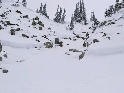
Saturday March 17 - yet another over-achieving storm system as snowfall begins overnight. By late in the day Saturday, totals from the Cottonwoods and Park City mountains ranged from 8-18" with 0.9-1.25" of SWE (snnow/water equivalent.) Avalanche activity was mostly within storm snow, but a few slides broke down into old snow. This included Upper Days Fork (photo) and Mount Millicent.

Sunday March 17 - Storm snow instabilities settle out, and continued snow showers leave totals (snow/SWE)
Cottonwoods 18-28" 1.5-1.75" Park City 10-18" 1.1-1.35"Minimal avalanche activity reported within storm snow. Several observations indicate generally stable snowpack.
Monday/Tuesday March 18/19 - Storm system departs with brief high pressure in its wake. Clear skies lead to minor wet loose activity. [Mark White photo]

Wednesday March 21 - Transitionday with clouds, increasing winds, and warmer temperatures ahead of atmospheric river event.
Thursday March 22 - Strong winds, warm temperatures, and rain to at least 9500'. By late in the day on Thursday several observations from the Cottonwoods reported about 1" of water. Wet loose avalanche activity reported at low and mid elevations.


