Forecast for the Skyline Area Mountains

Brett Kobernik
Issued by Brett Kobernik on
Thursday morning, March 15, 2018

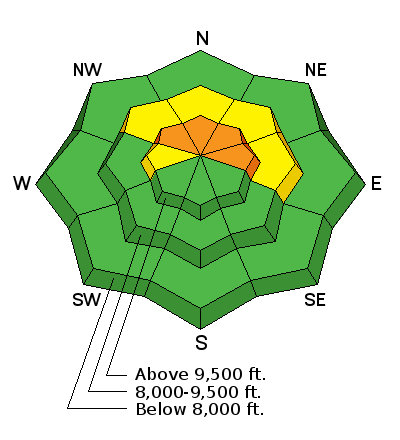
The avalanche danger is CONSIDERABLE in the upper elevation steep slopes that face northwest, north and east. Human triggered avalanches are likely on these slopes today. Wind driven heavy new snow is stressing the deeply buried weak snow in the snowpack and avalanches will break to the ground if you trigger one.

The avalanche danger will remain elevated or even increase over the weekend with additional new snow.

Low
Moderate
Considerable
High
Extreme
Learn how to read the forecast here
Special Announcements

We couldn't get out on the snow without the great support from Polaris, Ski Doo, and Arctic Cat as well as KTM and Timbersled. Our local dealers make it happen. Tri-City Performance, Weller Recreation, Northstar's Ultimate Outdoors, Big Pine and Morgan Valley Polaris. We use these machines to monitor the snowpack across the state of Utah. We also use these machines to teach life-saving classes.

Weather and Snow

The Skyline picked up about 6 inches of high density snow overnight in a strong southwest flow. It has stopped snowing as of now and the wind has slowed a bit. The rain-snow level started out quite high in the 8500 foot range or perhaps even a bit higher. Temperatures at most stations dropped into the mid 20s during the snowfall.

Ad
Additional Information

Issued by the National Weather Service:

Thursday: Snow showers. Some thunder is also possible. High near 25. West southwest wind 5 to 13 mph becoming south in the afternoon. Chance of precipitation is 90%. New snow accumulation of 2 to 4 inches possible.
Thursday Night: Snow showers likely, mainly before midnight. Mostly cloudy, with a low around 14. Breezy, with a west wind 18 to 23 mph decreasing to 10 to 15 mph after midnight. Chance of precipitation is 70%. New snow accumulation of 1 to 3 inches possible.
Friday: A 20 percent chance of snow showers after noon. Partly sunny, with a high near 29. West wind 6 to 11 mph becoming southeast in the afternoon.
Friday Night: A 20 percent chance of snow. Mostly cloudy, with a low around 19. South southeast wind 5 to 10 mph.
Saturday: Snow likely. Mostly cloudy, with a high near 26. Chance of precipitation is 60%. New snow accumulation of 1 to 3 inches possible.
Saturday Night: A 50 percent chance of snow showers. Mostly cloudy, with a low around 12. New snow accumulation of less than one inch possible.
Sunday: A chance of snow showers. Mostly cloudy, with a high near 21.

General Announcements

Support the Utah Avalanche Center through your everyday shopping. DETAILS HERE

We will publish full detailed advisories Saturday and Sunday mornings by 7am. We will also be publishing basic avalanche danger ratings & info during the week.

If you are getting out into the mountains, we love to hear from you! You can SUBMIT OBSERVATIONS ONLINE or EMAIL US

If you would like to have avalanche advisories emailed to you, SIGN UP HERE

We can provide basic avalanche awareness presentations for your school, group or club. To enquire, CLICK HERE