


Forecast for the Skyline Area Mountains

Sunday morning, March 4, 2018
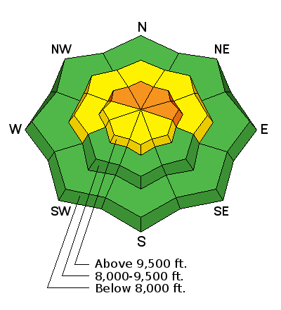
The avalanche danger is CONSIDERABLE on steep slopes that face northwest, and especially north and east. New snow and wind drifted snow are increasing the avalanche danger on these slopes. If you avoid the slopes mentioned, the avalanche danger is much lower and you can safely travel around.
 Weather and Snow
The Skyline picked up about 4 inches of snow as of 6am this morning. Southwest wind increased in speed overnight and was fairly strong. It is now shifting to a northwest direction and looks like it is slowing slightly. Mountain temperatures are in the mid to upper teens.

Persistent Weak Layer
Description
New snow along with wind drifted snow will increase the chance of triggering an avalanche that breaks into old weak sugary faceted snow buried deeper in the snowpack.
Wind Drifted Snow

Description
Fresh wind drifts probably won't pose a huge threat on their own today. While there may be some fresh wind slabs that crack out today, an avalanche that breaks into old snow is by far the biggest concern.
Additional Information
We should see snow showers during the day today with another 2 to 5 inches of snow possible. Wind will shift more northwest and should continue to slow down. Temperatures will drop during the day and will get down into the single digits by this evening. The storm moves out tonight and high pressure starts to move in for most of the week with clear skies and warming temperatures.
General Announcements
Support the Utah Avalanche Center through your everyday shopping. DETAILS HERE
We will publish full detailed advisories Saturday and Sunday mornings by 7am. We will also be publishing basic avalanche danger ratings & info during the week.
If you are getting out into the mountains, we love to hear from you! You can SUBMIT OBSERVATIONS ONLINE or EMAIL US
If you would like to have avalanche advisories emailed to you, SIGN UP HERE
We can provide basic avalanche awareness presentations for your school, group or club. To enquire, CLICK HERE