Issued by Eric Trenbeath for Saturday, February 24, 2018
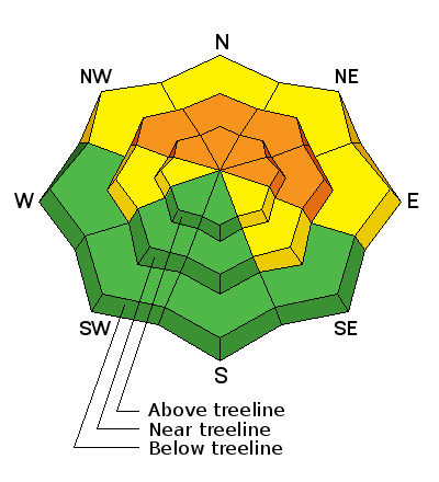
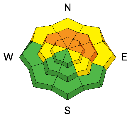
The avalanche danger remains CONSIDERABLE today on steep slopes that face NW-N-E right around treeline and above, especially on slopes that have recent deposits of wind drifted snow. Human triggered avalanches up to 3' deep are likely in these areas. Backcountry travelers need to practice cautious route finding and make conservative decisions. The avalanche danger is MODERATE below treeline.
The UAC Marketplace is still open. Our online marketplace still has deals on skis, packs, airbag packs, beacons, snowshoes, soft goods and much more.
Weather and Snow
Yesterday's storm turned out to be all blow and no snow, at least for the La Sal Mountains. Meanwhile to the south, heavy snow hit the Abajos with Buckboard Flat receiving 14" with much more up high. Neverthess, the La Sals have picked up about 15" of snow since Monday and conditions are greatly improved. The snowpack is still thin but we now have a skiable and rideable base with 42" on the ground at 10,000' in Gold Basin. Use caution and tread lightly as there are many obstacles lying just below the surface. Winds have finally tapered off and shifted to the NW blowing in the teens along the ridgetops. It's a frigid 0 degrees at the Geyser Pass Trailhead.
Base depth in Gold Basin: 42" Base depth at Geyser Pass Trailhead: 30"
Wind, temperature, and humidity on Pre Laurel Peak (11,700')
Road conditions to Geyser Pass Trailhead: Grand County plowed on Tuesday. The is snowpacked and icy in places. 4wd is recommended.
Grooming conditions: Trails were last groomed through Gold Basin on Tuesday.
Avalanche Problem #1
Persistent Weak Layer
Type
Location
Likelihood
Size
Description
We've added a little more weight to our fragile snowpack this week and though I haven't heard any recent reports of collapsing, stability tests continue to show propagation on weak, sugary, faceted snow at the base of the snowpack. In many areas the weight of a skier or rider is all that it will take to trigger a persistent slab avalanche up to 3' deep. The danger is greatest on steep slopes, right around treeline and above, that face NW-N-E, especially if these slopes are overloaded with recent deposits of wind drifted snow and human triggered avalanches remain likely in these areas.
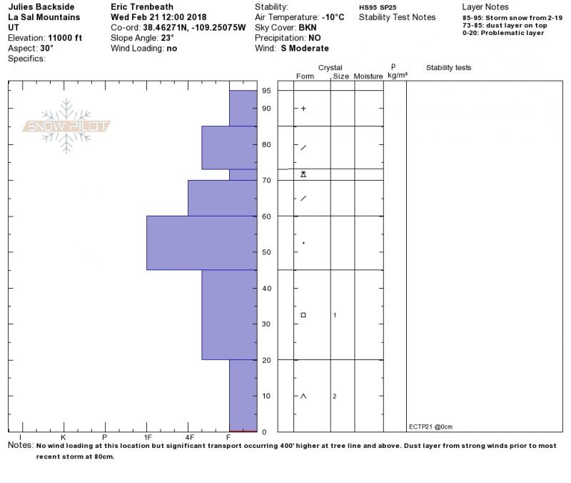
The snowpit below illustrates the unstable base we are dealing with. An extended column test produced propagation failure on weak, faceted snow at the ground. ECTP 21
Avalanche Problem #2
Wind Drifted Snow
Type
Location
Likelihood
Size
Description
Southerly winds throughout the week have created wind slabs in upper elevation, wind exposed terrain. Most of these slabs should be gaining some strength, but you should continue to avoid any steep slope where the snow has a smooth, rounded appearance, or where you can detect recent deposits of wind drifted snow. The danger is greatest on steep terrain right around treeline and above that faces NW-N-E. In these areas, a triggered wind slab has the very real potential to step down causing a deeper and more dangerous persistent slab avalanche.
Additional Information
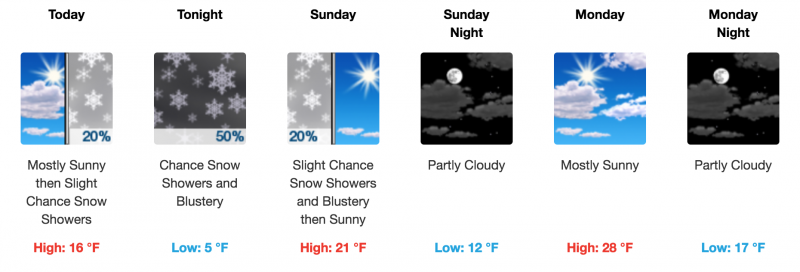
It's going to be mostly sunny and cold today with moderate WNW winds blowing along the ridge tops. High temps at 10,000' will be in the mid teens but wind chill factors will be well below zero. A few clouds later today will bring a chance for scattered showers tonight.
Benefit the Utah Avalanche Center when you buy or sell on eBay- set the Utah Avalanche Center as a favorite non-profit in your eBay account here and click on eBay gives when you buy or sell. You can choose to have your seller fees donated to the UAC, which doesn't cost you a penny
This information does not apply to developed ski areas or highways where avalanche control is normally done. This advisory is from the U.S.D.A. Forest Service, which is solely responsible for its content. This advisory describes general avalanche conditions and local variations always occur.