Planned Website Outage: The UAC website will be down for maintenance on June 17 from 2:00 - 7:00 PM MT.

Observation: Moffit Basin

Observation Date
2/22/2018
Observer Name
Kikkert
Region
Uintas » Bear River Ranger District » Bear River West Fork » Moffit Basin
Location Name or Route
Moffit Basin
Weather
Sky
Overcast
Precipitation
Light Snowfall
Wind Direction
South
Wind Speed
Moderate
Weather Comments
Winds light in the AM, increasing mid afternoon to moderate category. Temp warmed slightly over previous days, but still cold, especially in the wind. Cloud cover made it feel colder than the previous day, which was sunny. Some light showers started mid afternoon, but no accumulation.
Snow Characteristics
Snow Surface Conditions
Powder
Dense Loose
Snow Characteristics Comments

Good settled powder on all aspects and mid and upper elevations.

Red Flags
Red Flags
Poor Snowpack Structure
Red Flags Comments
Have not noticed any sensitive wind slabs the past couple days, and I think the cold temps have locked them up. Todays bump in winds didn't seem to do much. Some of the deeper persistent weak layers have begun to heal, but there are a lot of weak layers in our snowpack (see below).
Avalanche Problem #1
Problem
Persistent Weak Layer
Trend
Same
Problem #1 Comments

Lots of layers in our snowpack due to our prolonged dry spells this winter. Deeper weak layers (formed in early Dec.) that have been the most problematic have begun to heal, or are being bridged by around a meter or so of snow now on top of these layers. However, there were a couple cold nights on Feb 12 and 13th that led to the formation of near surface facets that were then buried with shallow wind slabs on the 14th and new snow on the 15th. This layer is now buried around 30 cm deep, primarily on north facing sloeps that were sheltered from the strong winds on the 14th. Test pits in upper elevation north facing terrain showed this layer to be sensitive. However, it seems like we just don't have quite enough of a slab (load) on top of it for avalanches (if we had gotten a bit more snow out of the last storm, we might be seeing more activity on it, like in the Wasatch). It will be something to watch tomorrow, if we get a decent amount of snow, particularly with wind, I would expect avalanches on this layer. I do expect this layer to heal fairly quickly, as it is not overly weak (see below).

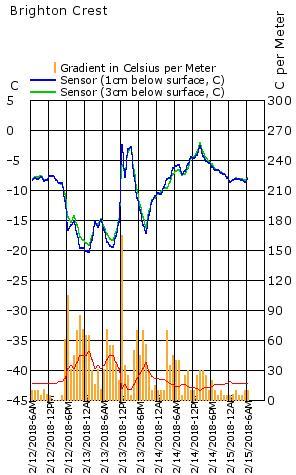
Chart shows temperature gradients recorded at Brighton from 2/12 to 2/15. Note that on the nights of the 12th and the 13th, gradients were nearly double that needed for faceting (anything above the red line).

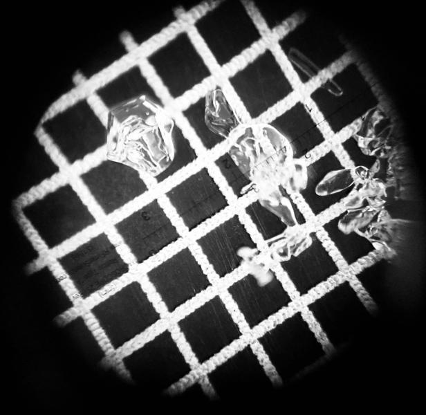
Photo is of snow crystals from the 2/12-2/13 layer of snow. Note the small faceted grain, but also small broken and rounding grains. The lack of really pronounced faceting leads me to think we won't be dealing with this layer as long as some others we have seen this year.

Today's Observed Danger Rating
Moderate
Tomorrows Estimated Danger Rating
Moderate