Forecast for the Skyline Area Mountains

Brett Kobernik
Issued by Brett Kobernik for
Sunday, February 18, 2018

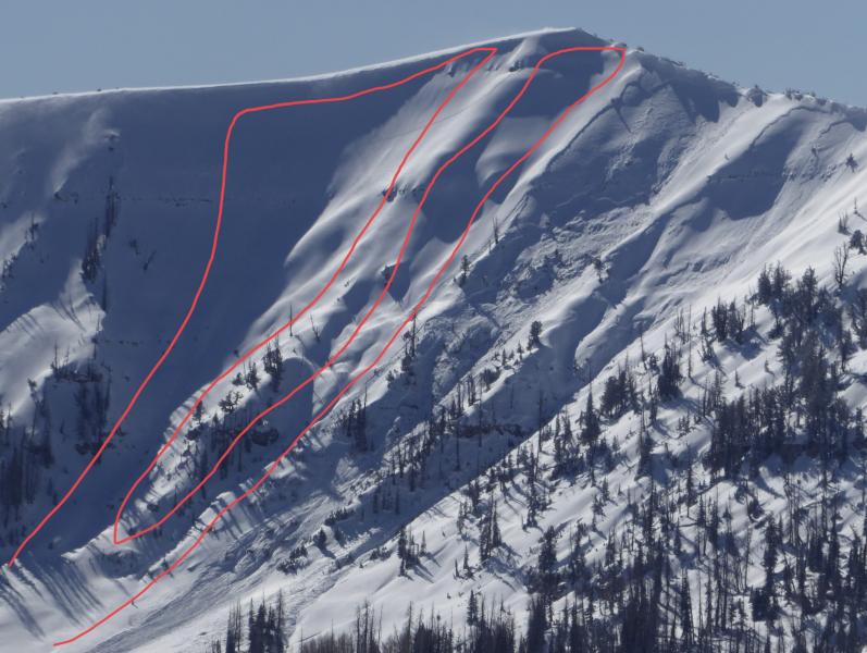
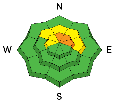
The avalanche danger is CONSIDERABLE on steep slopes above about 9500' in elevation that face north through east. Human triggered avalanches are likely in the terrain mentioned. Anticipate the avalanche danger to stay elevated or perhaps reach HIGH DANGER over the next few days as another storm moves through.
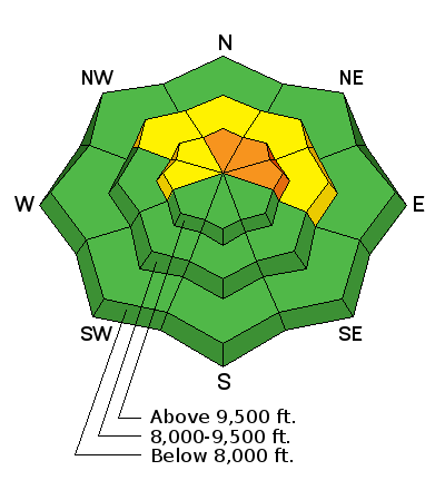
Low
Moderate
Considerable
High
Extreme
Learn how to read the forecast here
Avalanche Watch

* TIMING…THROUGH 6 AM MST MONDAY

* AFFECTED AREA…FOR THE ALL MOUNTAINS OF NORTHERN AND CENTRAL UTAH

* AVALANCHE DANGER…THE AVALANCHE DANGER FOR THE WARNING AREA IS CONSIDERABLE AND IS EXPECTED TO RISE TO HIGH OVERNIGHT.

* IMPACTS…STRONG WINDS TODAY WITH PERIODS OF HEAVY SNOW TONIGHT THROUGH TUESDAY WILL CREATE WIDESPREAD AREAS OF UNSTABLE SNOW. THE AVALANCHE DANGER WILL REMAIN ELEVATED THROUGH TUESDAY WITH BOTH HUMAN TRIGGERED AND NATURAL AVALANCHES BECOMING LIKELY. STAY OFF OF AND OUT FROM UNDER SLOPES STEEPER THAN 30 DEGREES.

Weather and Snow

Temperatures were very mild on Saturday. The wind was drifting snow along the higher ridges especially in the afternoon as it started to shift to a more southwest direction and increase in speed. Sun exposed slopes became damp. Slopes on the north side of the compass continued to provide excellent riding conditions.

The southwest wind has really increased in speed overnight and is strong across the ridges. It looks like it is getting down into the canyon bottoms also. Temperatures are quite mild with many stations in the upper 20s and low 30s.

Recent Avalanches

The southwest wind in the afternoon was drifting enough to produce some avalanche activity. I actually watched two large avalanches release in the Big Horseshoe at 2:30pm on Saturday. They ultimately took out all the snow to the ground which would've been in the 3 foot depth range or a bit more. Below is a photo from Friday that shows two other natural avalanches. I highlighted the two avalanches in red that I watched release on Saturday.

Ad
Avalanche Problem #1
Persistent Weak Layer
Type
Location
Likelihood
Size
Description

It's pretty straight forward right now. Buried weak snow from earlier in the winter is getting overloaded with new snow and wind loaded snow. Human triggered and natural avalanches have been occurring for the last 3 days. Strong wind again today may drift enough snow to produce natural avalanches again. The buried weak snow will remain a dangerous situation for the near future.

Additional Information

Southwest wind will be strong all day today. Clouds will increase and temperatures will remain fairly mild. A storm will sweep through the entire state tonight and through Monday starting to clear out Tuesday. Temperatures are going to be very cold with this storm and snow densities will be very low. After the cold front moves through tonight, wind will shift to the northwest and slow dramatically. We'll see snow most of the day on Monday. I'm expecting 6 to 11 inches of new snow by Tuesday.

General Announcements

Support the Utah Avalanche Center through your everyday shopping. DETAILS HERE

We will publish full detailed advisories Saturday and Sunday mornings by 7am. We will also be publishing basic avalanche danger ratings & info during the week.

If you are getting out into the mountains, we love to hear from you! You can SUBMIT OBSERVATIONS ONLINE or EMAIL US

If you would like to have avalanche advisories emailed to you, SIGN UP HERE

We can provide basic avalanche awareness presentations for your school, group or club. To enquire, CLICK HERE