Forecast for the Ogden Area Mountains

Friday morning, February 9, 2018
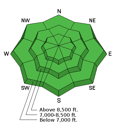
The snow is stable in most areas and avalanches are generally unlikely. But LOW danger does not mean no danger.
You might trigger cornice falls and/or shallow wind slab avalanches on drifted slopes at upper elevations. And avalanches stepping into old snow remain possible on isolated steep slopes with poor snow structure. Avoid steep slopes that have high consequences like cliffs, trees, or gullies below.

 Special Announcements
The UAC Marketplace is still open. Our online marketplace still has deals on skis, packs, airbag packs, beacons, snowshoes, soft goods and much more.
Benefit the Utah Avalanche Center when you buy or sell on eBay - set the Utah Avalanche Center as a favorite non-profit in your eBay account here and click on eBay gives when you buy or sell. You can choose to have your seller fees donated to the UAC, which doesn't cost you a penny
 Weather and Snow
It’s yet another warm and windy morning - temperatures are in the mid 40's F at low elevation trail heads and mid to upper 30's F around 8000'. The winds are from the west southwest, averaging 10 to 20 mph, with the highest peak (Mt Ogden) seeing gusts over 45 mph.
Traveling conditions run the gamut, minus any classic Utah powder. Surface snow is a highly variable mix of breakable, shallow wind crusts, rain/rime crusts, wind buff, shallow soft snow, etc. We found small areas of "corn" snow yesterday but no more than a handful of turns. Sheltered lower angle slopes that harbor a bit of softer snow are still offering the best riding conditions. Lower elevation trail heads are getting very thin with the recent warm temps.
What was most noticeable yesterday was the loss of total snow height. I visited the same site a few weeks apart and found that the total height had shrunk from 115 cm to 75 cm mostly due to the recent run of warm temperatures.
 Recent Avalanches
No recent avalanche activity has been reported from the Ogden area mountains.
Persistent Weak Layer

Description
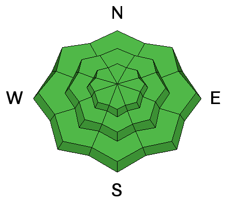
Although unlikely, persistent slab avalanches remain possible in isolated steep terrain. The most experienced people are still avoiding the bulls-eye terrain - steep, north and northeast facing slopes, especially those that are rocky, wind loaded or have a shallow snowpack. These are the slopes where you are most likely to trigger one of these deeper slab avalanches.
· Widespread buried faceted layers appear dormant now, and persistent slab avalanches are unlikely, but if you trigger one it will be dangerous.
· If you choose to travel on steep slopes, select slopes with clean run outs, where a mistake in your stability evaluation won’t send you rocketing off a cliff, into trees or into a gully.
· Pay attention to possible signs of instability like cracking and whumpfing or collapsing, but remember these signs are not likely to be present so you have to dig down and look for the poor snow structure.

NE facing slope near 8800' on 2/8/18
Normal Caution

Description
Wind Slabs: As always, avoid any old or new wind drifts on steep slopes. They often look smooth and rounded, will mostly be along or near upper elevation ridge lines.
Cornices: Avoid travel on and below any new and old cornices.
Loose Wet: Avoid slopes that become saturated with daytime heating and/or direct sun. If you start seeing signs of instability like rollerballs, it's time to move to a cooler aspect or lower angle slope.
Additional Information
The forecast today calls for partly sunny skies and mountain temps in the 30's F. Westerly winds will blow 15 to 20 mph with ridgetop gusts a bit higher. Winds will strengthen a bit this afternoon ahead of a small disturbance moving into the area that will bring with it much colder temperatures and a small chance of snow on Saturday. Cold temps remain in place long enough for it to feel like winter again. Another system swings through on Sunday night with yet another chance for an inch or two.
General Announcements
CLICK HERE FOR MORE GENERAL INFO AND FAQ
The UAC has new support programs with Outdoor Research and Darn Tough. Support the UAC through your daily shopping. When you shop at Smith's, or online at Outdoor Research, REI, Backcountry.com, Darn Tough, Patagonia, NRS, Amazon, eBay a portion of your purchase will be donated to the FUAC. See our Donate Page for more details on how you can support the UAC when you shop.
Benefit the Utah Avalanche Center when you buy or sell on eBay - set the Utah Avalanche Center as a favorite non-profit in your eBay account here and click on eBay gives when you buy or sell. You can choose to have your seller fees donated to the UAC, which doesn't cost you a penny
This information does not apply to developed ski areas or highways where avalanche control is normally done. This advisory is from the U.S.D.A. Forest Service, which is solely responsible for its content. This advisory describes general avalanche conditions and local variations always occur.


