Observation: White Pine

Observation Date
2/5/2018
Observer Name
Evelyn
Region
Salt Lake » Little Cottonwood Canyon » White Pine
Location Name or Route
White Pine, LCC
Weather
Sky
Overcast
Precipitation
Light Snowfall
Weather Comments
Another gray day, with light graupel showers in the morning. Clouds lifting a bit by noon, with even a few breaks in the cloud cover. Calm at the lower elevations, and warm, once again. Rain/snow line had dropped to around 7,200' on the drive up at 9 am.
Snow Characteristics
New Snow Depth
1"
New Snow Density
High
Snow Surface Conditions
Dense Loose
Melt-Freeze Crust
Rain-Rime Crust
Damp
Snow Characteristics Comments

Trace of new snow at the trailhead, 1" up high - all graupel. Improved turning on low angle slopes, even with just the inch of new snow. Graupel pooling below any smooth, slick steep slopes - up to 6" deep.

Red Flags
Red Flags
Poor Snowpack Structure
Red Flags Comments
A warm snowpack at these 2 lower/mid elevation spots, but still both pits had weak facet layers and slabs. Over time, it would seem the warm temps and warm snow is a good thing for the snowpack. With a lack of a significant temperature gradient in the snowpack, strengthening and bonding should occure rather than faceting.
Snow Profile
Aspect
North
Elevation
7,800'
Slope Angle
30°
Comments

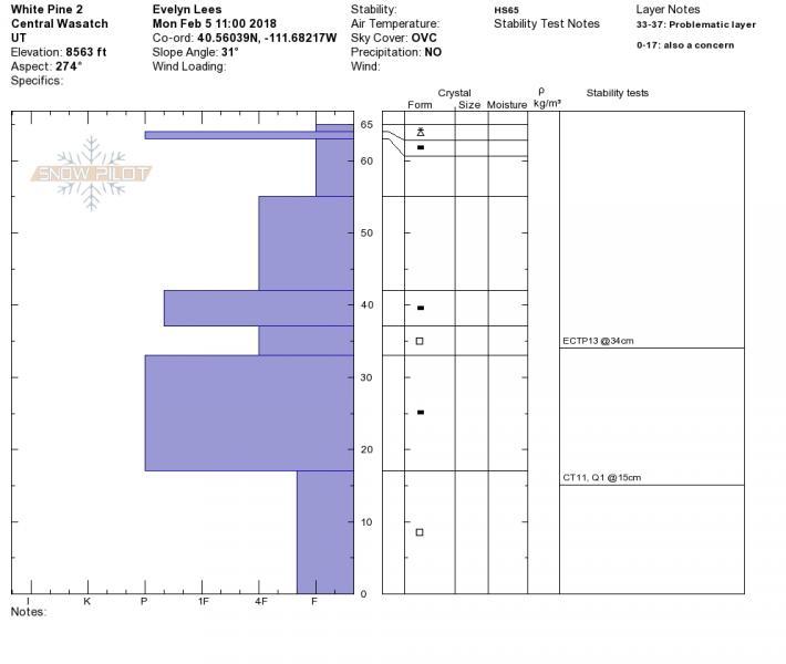
Above profile: Snow was moist, top to bottom, but didn't seem "wet" or to have free water. Still a layered snow pack, and but even with full propagation on ECT the snow seemed sluggish and unreactive. No cracking or collapsing. Photo of pit below.

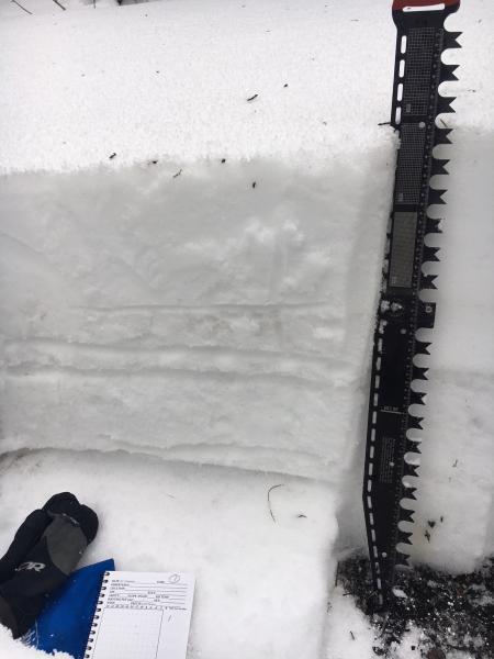
Pit below: facet layer at 33 - 37 cm, above the thicker ice crust seemed the weakest layer, both with traditional and untraditional tests. However, pit was in a poor spot to really test the basal facets (ground too rocky and uneven). And they were falling out of the pit wall in places.

With cooling overnight and tomorrow, low danger for the lower/mid elevations. Didn't visit upper elevation, wind affected terrain. Sluffing possible in places with deep graupel pooling.

Today's Observed Danger Rating
Low
Tomorrows Estimated Danger Rating
Low
Coordinates