Forecast for the Abajo Area Mountains

Eric Trenbeath
Issued by Eric Trenbeath for
Monday, January 22, 2018

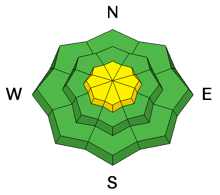
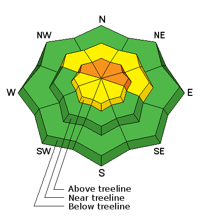
The avalanche danger is CONSIDERABLE today. Dangerous avalanche conditions exist and human triggered avalanches are likely on steep, mid and upper elevation slopes that face NW-N-E. Backcountry travelers should avoid avalanche terrain in these areas by staying off of and out from under steep, or locally connected slopes.

Low
Moderate
Considerable
High
Extreme
Learn how to read the forecast here
Special Announcements

We've scheduled our annual Backcountry 101 avalanche course for Feb 2,3. For more information or to register go here.

We've also scheduled a Motorized Backcountry 101 for snowmobiles and snowbikes. For more information or to register go here.

Weather and Snow

Finally some significant snow! Buckboard Flat picked up 10" of new bringing the base up to 16". Coverage remains very thin, but this looks like it could finally be the beginning of winter.

Skies are mostly clear this morning, ridge top winds are light and northwesterly, and it's 10 degrees at 9000'.

Wind, temperature and humidity on Abajo Peak (11,000')

Snow totals at Buckboard Flat (8924')

Snow totals at Camp Jackson (8858')

Avalanche Problem #1
Persistent Weak Layer
Type
Location
Likelihood
Size
Description

The existing snowpack is very shallow and weak, and the new snow load has created dangerous persistent slab conditions on steep, upper elevation slopes that face NW-N-E. Backcountry travelers should avoid this kind of terrain. Telltale signs of instability include whoomphing sounds and collapsing of the snowpack.

Avalanche Problem #2
Wind Drifted Snow
Type
Location
Likelihood
Size
Description

Increasing winds today will move blow the loose snow around forming dangerous drifts on the lee sides of upper elevation ridge crests and terrain features. Look for signs of instability such as cracking in the snow surface, and avoid smooth rounded deposits of wind drifted snow.

Additional Information

Today look for mostly sunny skies with high temps near 10,000' to be in the low 20's. Dry and sunny conditions remain until Thursday when a weak storm system primarily affecting regions north will bring clouds and a chance of snow to our area.

General Announcements

Support the UAC through your daily shopping. When you shop at Smith's, or online at REI, Backcountry.com, Patagonia, NRS, Amazon, eBay a portion of your purchase will be donated to the FUAC. See our Donate Page for more details on how you can support the UAC when you shop.

Benefit the Utah Avalanche Center when you buy or sell on eBay - set the Utah Avalanche Center as a favorite non-profit in your eBay account here and click on eBay gives when you buy or sell. You can choose to have your seller fees donated to the UAC, which doesn't cost you a penny

This information does not apply to developed ski areas or highways where avalanche control is normally done. This advisory is from the U.S.D.A. Forest Service, which is solely responsible for its content. This advisory describes general avalanche conditions and local variations always occur.