

Forecast for the Skyline Area Mountains

Thursday morning, January 11, 2018
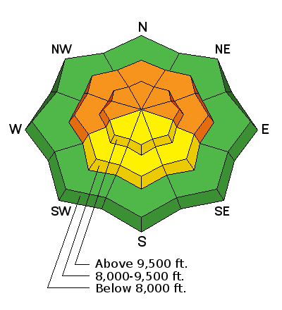
The avalanche danger is CONSIDERABLE today on the mid and upper elevation slopes approaching 35 degrees or steeper that face west, north and east. Natural avalanches are not expected but human triggered avalanches are very likely on these slopes. Collapsing or "whoomping" and cracking of the snowpack are significant signs of avalanche danger.
 Special Announcements
Be sure to join us at Big Pine Sports on Thursday, January 25th for a free avalanche presentation. DETAILS HERE
We are offering a Motorized Backcountry 101 avalanche class on February 10th. DETAILS HERE
 Weather and Snow
Storm totals were less than I expected, hence the avalanche danger did not reach HIGH DANGER on Wednesday as I expected it would. However, there was enough new snow to create a slab and widespread collapsing and cracking when traveling on skis and snowshoes. Storm totals are around 6" across the Manti Skyline. It looks like the Fish Lake region did slightly better with upwards of 12" at the Farnsworth Snotel site.
For some more details on conditions from Wednesday, CLICK HERE.

Additional Information

General Announcements
Support the Utah Avalanche Center through your everyday shopping. DETAILS HERE
We will publish full detailed advisories Saturday and Sunday mornings by 7am. We will also be publishing basic avalanche danger ratings & info during the week.
If you are getting out into the mountains, we love to hear from you! You can SUBMIT OBSERVATIONS ONLINE or EMAIL US
If you would like to have avalanche advisories emailed to you, SIGN UP HERE
We can provide basic avalanche awareness presentations for your school, group or club. To enquire, CLICK HERE