Forecast for the Skyline Area Mountains

Brett Kobernik
Issued by Brett Kobernik for
Friday, March 31, 2017

The avalanche danger is still generally LOW this morning. It may rise to MODERATE if we see more snow and wind than anticipated. Watch for any increase in wind where the new snow starts getting drifted. Drifts will likely form in areas where they usually don't due to the east wind direction today.
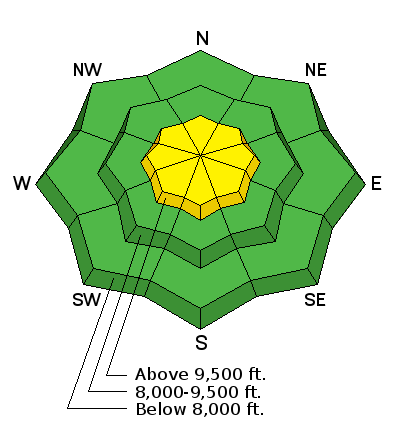
Low
Moderate
Considerable
High
Extreme
Learn how to read the forecast here
Weather and Snow

The rain snow line was around the 8500 foot level on Thursday when snow started about 2pm. We picked up 3 inches by the evening. Another inch fell overnight bringing us up to 4 inches total since Thursday. Overnight the temperatures were around 30˚F. The wind direction has shifted more to the east and is in the moderate speed range.

Ad
Additional Information

As the storm pulls away from us, we'll see an east wind flow today with mostly cloudy skies. It doesn't look like the wind will get real strong but I've been duped before with east wind. The flow shifts more north tonight. I think we'll see 2 to 4 inches more snow by the end of the storm tonight. The weekend looks pretty nice with some clouds. Another storm is shaping up for Monday.

General Announcements

We will publish full detailed advisories Saturday and Sunday mornings by 7am. We will also be publishing basic avalanche danger ratings & info during the week.

If you are getting out into the mountains, we love to hear from you! You can SUBMIT OBSERVATIONS ONLINE or EMAIL US

If you would like to have avalanche advisories emailed to you, SIGN UP HERE

We can provide basic avalanche awareness presentations for your school, group or club. To enquire, CLICK HERE