


Forecast for the Ogden Area Mountains

Saturday morning, March 25, 2017
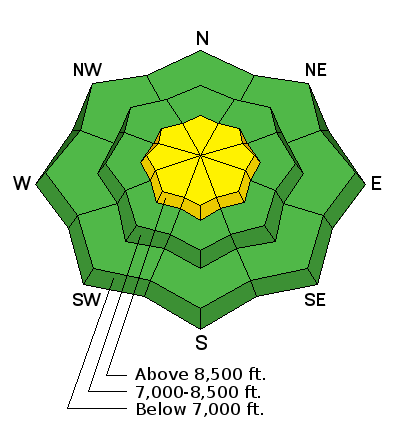
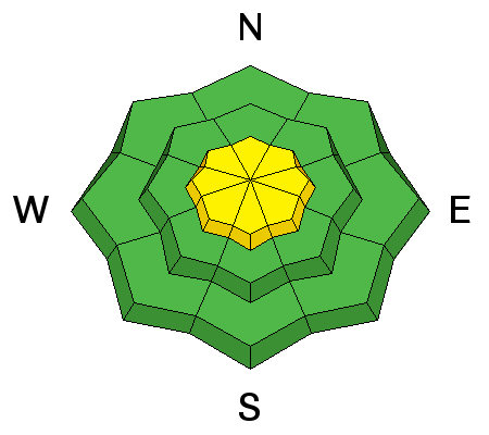
The avalanche danger is MODERATE today as winds and snow will create heightened avalanche conditions at upper elevations for wind slabs and cornices. At mid and low elevations, conditions are generally safe and the avalanche danger is LOW.
 Special Announcements
“I try to do the right thing at the right time. They may just be little things, but usually they make the difference between winning and losing.” - Kareem Abdul Jabbar
Be sure to check out the last installment of the The Little Things - habits that might keep you alive, a four part series of tricks and tidbits to help keep you on top picked up by one of our observers during years of mostly incident-free wandering in the backcountry by ski, foot, and boat.
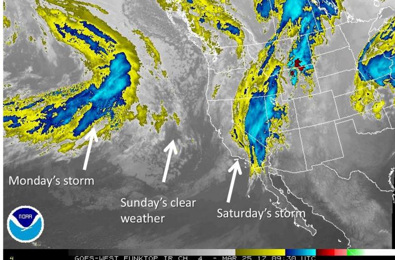
 Weather and Snow
If you don't like the weather, just wait a day, so if you liked the sun and warmth yesterday, it's not likely you'll be too excited to get out today. Mountain temperatures are in the mid 30's F and winds, which were strong from the southwest overnight, have relaxed a little and are now northwest at 10-15 mph with ridgetop gusts a bit higher. It is snowing in the mountains and raining at the lower elevation trailheads.
Riding conditions will be a mixed bag today with crusts, damp snow and a bit of new, drier snow. The sun managed to dampen the snow yesterday on most aspects and elevations save due north shaded terrain.
 Recent Avalanches
Observers noted minor wind slab activity yesterday at upper elevations as well as wet activity once temperatures warmed. We were able to easily initiate shallow pushalanches on sun-affected steep slopes that entrained more snow as they descended.

Wind Drifted Snow
Description
With a winter weather advisory for the Ogden mountains, expect to see wind drifts develop, especially in upper elevation terrain. Because the existing snow surface is variable some areas will see good bonding while others may slide on previously scoured, frozen surfaces. Look for obvious signs of instability like cracking or collapsing. Avoid steep slopes with freshly wind drifted snow.
Depending on how the new snow bonds to the existing snow as well as itself, you may also see loose dry activity as the day progresses. Observe how the snow behaves, especially on steeper slopes. If it sluffs easily, you'll want to avoid that terrain.
Cornice
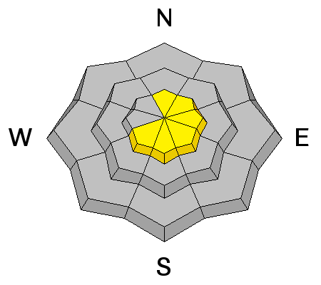
Description
Cornices: Cornices will get a bit bigger today with forecast snow and wind. Signs of failing cornice like cracks will be hidden beneath the new snow today and hard to identify. Avoidance is key – don’t travel beneath cornices and stay well back from the edges. Cornices tend to break well back onto what looks like flat terrain.
Wet Snow
Description
With temperatures expected to be cooler but still above freezing there is still a chance, albeit minimal, for triggering loose wet avalanches today. Without direct heating from the sun and relatively cool forecast temperatures, any wet activity will be limited to steep slopes where the snowpack is still very saturated. If the sun does manage to peak through today, the likelihood for wet avalanches will increase.
Additional Information
Snow fall amounts today will be about 3-6 inches with the rain/snow line around 7000 feet. Snowfall should end late today with clear sunny skies for Sunday. Temperatures today will rise into the mid 30's F but a lack of sunshine and a passing cold front will keep it from feeling very warm. Today's winds will be gusty and shift from the SW to NW by late today. They will average 10 mph but gusts will be a bit stronger.
General Announcements
|
Remember your information can save lives. If you see anything we should know about, please help us out by submitting snow and avalanche conditions. You can also call us at 801-524-5304, email by clicking HERE, or include #utavy in your tweet or Instagram. To get help in an emergency (to request a rescue) in the Wasatch, call 911. Be prepared to give your GPS coordinates or the run name. Dispatchers have a copy of the Wasatch Backcountry Ski map. Backcountry Emergencies. It outlines your step-by-step method in the event of a winter backcountry incident. If you trigger an avalanche in the backcountry, but no one is hurt and you do not need assistance, please notify the nearest ski area dispatch to avoid a needless response by rescue teams. Thanks.
EMAIL ADVISORY If you would like to get the daily advisory by email you will need to subscribe here. DAWN PATROL Hotline updated daily by 5-530am - 888-999-4019 option 8. TWITTER Updates for your mobile phone - DETAILS UDOT canyon closures: LINK TO UDOT, or on Twitter, follow @UDOTavy, @CanyonAlerts or @AltaCentral Utah Avalanche Center mobile app - Get your advisory on your iPhone along with great navigation and rescue tools. Powderbird Helicopter Skiing - Blog/itinerary for the day Lost or Found something in the backcountry? - http://nolofo.com/ To those skinning uphill at resorts: it is critical to know the resort policy on uphill travel. You can see the uphill travel policy for each resort here. Benefit the Utah Avalanche Center when you shop from Backcountry.com or REI: Click this link for Backcountry.com or this link to REI, shop, and they will donate a percent of your purchase price to the UAC. Both offer free shipping (with some conditions) so this costs you nothing! Benefit the Utah Avalanche Center when you buy or sell on ebay - set the Utah Avalanche Center as a favorite non-profit in your ebay account here and click on ebay gives when you buy or sell. You can choose to have your seller fees donated to the UAC, which doesn't cost you a penny. This information does not apply to developed ski areas or highways where avalanche control is normally done. This advisory is from the U.S.D.A. Forest Service, which is solely responsible for its content. This advisory describes general avalanche conditions and local variations always occur. |