Forecast for the Skyline Area Mountains

Brett Kobernik
Issued by Brett Kobernik for
Saturday, March 18, 2017

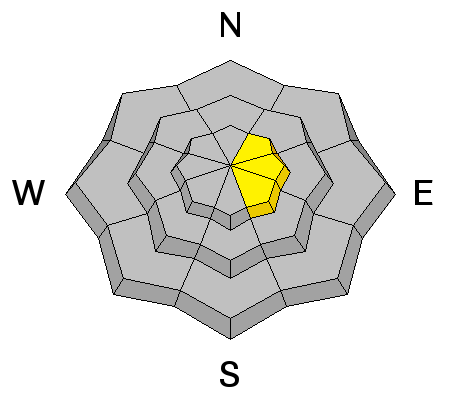
The avalanche danger starts out LOW this morning and may increase to MODERATE during the day with daytime heating. Natural wet avalanches are possible later today and cornices may also break off naturally. Avoid large steep slopes later in the day as the snow becomes really wet.
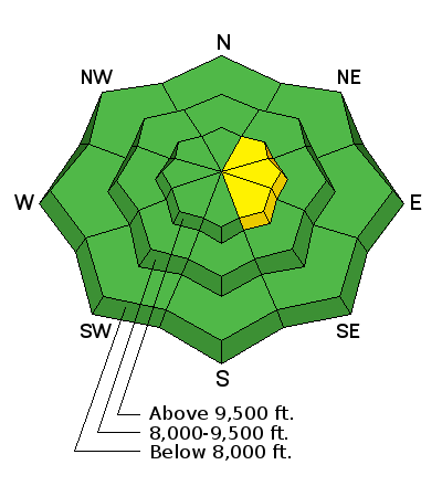
Low
Moderate
Considerable
High
Extreme
Learn how to read the forecast here
Weather and Snow

We have had a very mild week of weather with spring time conditions in full effect. Overnight low temperatures along the upper elevations have been above freezing since early in the week. However, we've had clear overnight sky cover most nights which has allowed the snow surface to freeze through long wave radiation loss. This has helped keep the snowpack generally stable.

Recent Avalanches

There has been no significant avalanche activity reported. I have seen some minor cornice falls and some minor snowmobile triggered wet loose avalanches. None of this was significant enough to get really worried about.

Ad
Avalanche Problem #1
Wet Snow
Type
Location
Likelihood
Size
Description

Wet avalanche activity is always a concern in the spring time but seldom actually presents a whole lot of danger. If you are concerned about it, the easiest way to avoid problems is to exit the mountains before the snow is wet, punchy and sloppy. I exited the mountains around 1pm on Friday. I was able to travel on most any steep slope without concern of avalanches before that time.

Avalanche Problem #2
Cornice
Type
Location
Likelihood
Size
Description

It is wise to avoid the large overhanging cornices. It is difficult to predict when they will crack off but they often do during warm weather like we're seeing right now.

Additional Information

Today will be the warmest day of the week with ridge top highs around 50. South wind will be light to moderate in speed. Sunday looks like another warm spring day. The pattern starts to change on Monday with some weather disturbances moving through. The best chance for snow looks like Wednesday. I'll take a more detailed look at the potential storms for the Sunday advisory.

General Announcements

We will publish full detailed advisories Saturday and Sunday mornings by 7am. We will also be publishing basic avalanche danger ratings & info during the week.

If you are getting out into the mountains, we love to hear from you! You can SUBMIT OBSERVATIONS ONLINE or EMAIL US

If you would like to have avalanche advisories emailed to you, SIGN UP HERE

We can provide basic avalanche awareness presentations for your school, group or club. To enquire, CLICK HERE