Forecast for the Skyline Area Mountains

Brett Kobernik
Issued by Brett Kobernik for
Wednesday, March 15, 2017

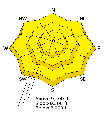
The avalanche danger is increasing as temperatures continue to stay warm. There is a MODERATE danger of triggering a wet avalanche today. Natural wet avalanches are possible. Cornices may start to break off naturally. Avoid being below large steep slopes that have become really wet and sloppy.

Low
Moderate
Considerable
High
Extreme
Learn how to read the forecast here
Weather and Snow

Last night was the second consecutive night with low temperatures above freezing in the mountains. Most stations were in the upper 30s.

Ad
Avalanche Problem #1
Wet Snow
Type
Location
Likelihood
Size
Description

The danger for wet avalanches is increasing with no solid overnight refreeze of the snowpack. It is difficult to say if we'll see any significant avalanche activity because timing of wet avalanches is hard to predict. Two to three nights with no refreeze is generally needed before any significant activity occurs.

  • The chance for triggering a loose wet avalanche increases during the day as the snow becomes wet and sloppy
  • Cornices are large and should not be trusted. They often start to break off at this time of the season especially during warm days.
Additional Information

General Announcements

We will publish full detailed advisories Saturday and Sunday mornings by 7am. We will also be publishing basic avalanche danger ratings & info during the week.

If you are getting out into the mountains, we love to hear from you! You can SUBMIT OBSERVATIONS ONLINE or EMAIL US

If you would like to have avalanche advisories emailed to you, SIGN UP HERE

We can provide basic avalanche awareness presentations for your school, group or club. To enquire, CLICK HERE