Forecast for the Abajo Area Mountains

Eric Trenbeath
Issued by Eric Trenbeath for
Monday, March 6, 2017

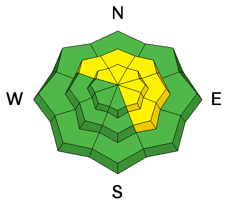
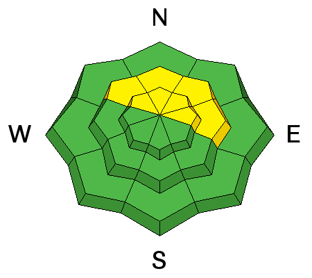
The avalanche danger is MODERATE today and backcountry travelers will need to be alert to newly formed wind slabs on the lee sides of ridge crests and terrain features in wind exposed terrain. There also remains an isolated, or MODERATE danger for triggering an avalanche on a buried weak layer on steep slopes right around tree line and above that face NW-N-NE.
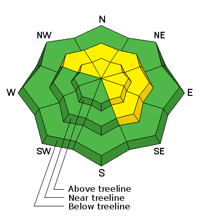
Low
Moderate
Considerable
High
Extreme
Learn how to read the forecast here
Special Announcements

The Abajo/Blue Mountain avalanche advisory will provide detailed information on the weekends. During the week, general information and a danger rating will be posted.

Weather and Snow

2-4" of new snow has fallen in the Abajo Mountains overnight with possibly higher amounts in the upper elevations. Southwest winds howled all day yesterday in the 30-40 mph range with gusts over 50. They've backed off a little this morning and have shifted to more westerly. They will continue to blow today in the 20-30 mph range. Temperatures have plummeted andare in the low teens around 10,000'.

Avalanche Problem #1
Wind Drifted Snow
Type
Location
Likelihood
Size
Description

The new snow hasn't been a huge contributor to a rising avalanche danger, but the strong winds have, and today you will need to be alert to recently formed wind slabs on the lee sides of ridge crests and terrain features in wind exposed terrain.

Avalanche Problem #2
Persistent Weak Layer
Type
Location
Likelihood
Size
Description

Areas with weak, underlying snow still exist, and though not widespread, there are a few areas out there where you could trigger an avalanche on a buried weak layer. Most likely areas are on steep slopes right around tree line and above that face the north half of the compass.

Additional Information

Cold air is filtering into the area behind a strong cold front. Expect much cooler temperatures today with highs at 10,000' to be in the upper teens. Gusty, westerly winds will continue to blow in the 20-30 mph range with gusts near 50. Lingering snow showers may bring another 2-4".

General Announcements

If you are getting out into the mountains, we love to hear from you! You can SUBMIT OBSERVATIONS ONLINE

If you would like to have avalanche advisories emailed to you, SIGN UP HERE

Benefit the Utah Avalanche Center when you shop from Backcountry.com or REI: Click this link for Backcountry.com or this link to REI, shop, and they will donate a percent of your purchase price to the UAC. Both offer free shipping (with some conditions) so this costs you nothing!

Benefit the Utah Avalanche Center when you buy or sell on ebayIf you sign up for AmazonSmile and designate the Utah Avalanche Center as your favorite charity, they will donate a portion of everything you spend to the UAC. I doesn't cost you a penny and we'd really appreciate the help.​

The information in this advisory is from the US Forest Service which is solely responsible for its content. This advisory describes general avalanche conditions and local variations always occur.