Forecast for the Skyline Area Mountains

Brett Kobernik
Issued by Brett Kobernik for
Monday, March 6, 2017

A CONSIDERABLE avalanche danger exists on any steep slopes where the wind has been drifting snow. Human triggered avalanches are likely and natural avalanches are possible especially along the ridges. Out of wind affected areas the danger is MODERATE. Let the storm run it's course before getting into big steep terrain.
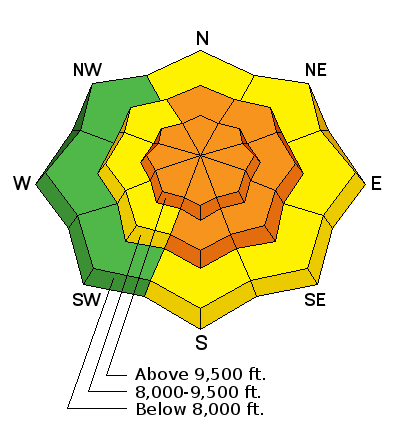
Low
Moderate
Considerable
High
Extreme
Learn how to read the forecast here
Weather and Snow

8 to 10" of snow has accumulated overnight and currently we're seeing a period of intense snowfall. The howling south wind on Sunday has switched to the northwest and has slowed some but it's still fairly breezy. Temperatures have dropped into the single digits. The new snow most likely bonded well to the old snow surface. The wind is what is making things dangerous forming drifts and slabs that people are likely to trigger today.

This storm fits the pattern that we've been in most of the winter. We see the avalanche danger increase during the storms and then the snow stabilizes fairly rapidly after the storm is done.

Ad
Additional Information

The storm will continue through today but will be winding down. A few more inches of snow is possible. It'll stay somewhat windy through the day from the west. High temperatures should get into the mid teens. We'll see a significant warming trend through the end of the week.

General Announcements

We will publish full detailed advisories Saturday and Sunday mornings by 7am. We will also be publishing basic avalanche danger ratings & info during the week.

If you are getting out into the mountains, we love to hear from you! You can SUBMIT OBSERVATIONS ONLINE or EMAIL US

If you would like to have avalanche advisories emailed to you, SIGN UP HERE

We can provide basic avalanche awareness presentations for your school, group or club. To enquire, CLICK HERE