

Forecast for the Abajo Area Mountains

Friday morning, March 3, 2017
The avalanche danger is MODERATE and human triggered avalanches are possible on steep slopes with recent deposits of wind drifted snow primarily on slopes with a northerly aspect. With daytime heating, may we see some loose, wet activity on sun exposed slopes. Look for signs of instability such as pinwheels, or roller balls, and sloppy wet snow.
 Special Announcements
The Abajo/Blue Mountain avalanche advisory will provide detailed information on the weekends. During the week, general information and a danger rating will be posted.
 Weather and Snow
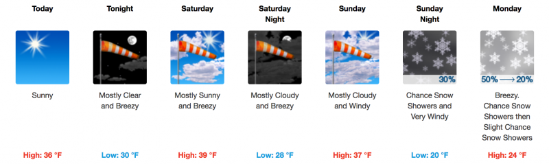
A beautiful day is on tap with sunny skies and increasing light to moderate southwesterly winds. 8" of snow fell earlier in the week but a string sun over the past couple of days will have formed a crust on sunny aspects. Wind exposed slopes have taken a hit as well, you'll need to seek shelter for soft snow.
Additional Information
General Announcements
If you are getting out into the mountains, we love to hear from you! You can SUBMIT OBSERVATIONS ONLINE
If you would like to have avalanche advisories emailed to you, SIGN UP HERE
Benefit the Utah Avalanche Center when you shop from Backcountry.com or REI: Click this link for Backcountry.com or this link to REI, shop, and they will donate a percent of your purchase price to the UAC. Both offer free shipping (with some conditions) so this costs you nothing!
Benefit the Utah Avalanche Center when you buy or sell on ebayIf you sign up for AmazonSmile and designate the Utah Avalanche Center as your favorite charity, they will donate a portion of everything you spend to the UAC. I doesn't cost you a penny and we'd really appreciate the help.
The information in this advisory is from the US Forest Service which is solely responsible for its content. This advisory describes general avalanche conditions and local variations always occur.