Forecast for the Skyline Area Mountains

Brett Kobernik
Issued by Brett Kobernik for
Friday, February 24, 2017

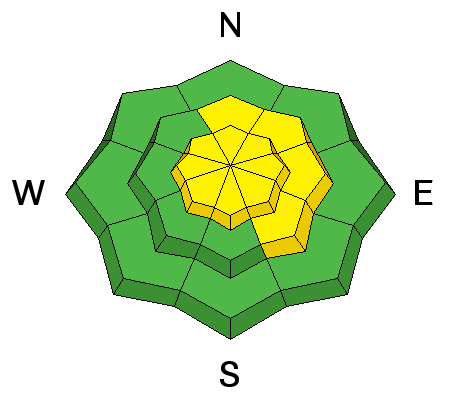
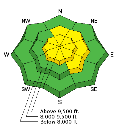
The overall avalanche danger is MODERATE today. The most dangerous places are along the higher north through southeast facing steep slopes where the wind has drifted snow into deeper drifts and slabs. If you avoid wind effected terrain, you will avoid being in avalanche danger today.

Low
Moderate
Considerable
High
Extreme
Learn how to read the forecast here
Weather and Snow

A few more inches of snow trickled in over the last 24 hours bringing snow totals up to about 10 inches since Wednesday. West wind is gradually slowing down but still slightly gusty along the highest terrain. Mountain temperatures are around 10˚F.

Ad
Avalanche Problem #1
Wind Drifted Snow
Type
Location
Likelihood
Size
Description

Wind drifts and wind slabs that formed on Thursday may still be sensitive today. These drifts probably won't be as sensitive today as they were when they were forming on Thursday. The wind may bump up in speed a bit as the day progresses so this could drift a little more snow along the ridges.

Additional Information

The current storm is slowly moving east but clouds and the chance for some snow will remain through the day today. West northwest wind may increase a bit but I would still call it moderate speed. Mountain high temperatures will get into the mid teens. We'll see cloudy skies on Saturday with a minor disturbance moving through late in the day into the night. Sunday looks like a nice day and then another storm moves in on Monday.

General Announcements

We will publish full detailed advisories Saturday and Sunday mornings by 7am. We will also be publishing basic avalanche danger ratings & info during the week.

If you are getting out into the mountains, we love to hear from you! You can SUBMIT OBSERVATIONS ONLINE or EMAIL US

If you would like to have avalanche advisories emailed to you, SIGN UP HERE

We can provide basic avalanche awareness presentations for your school, group or club. To enquire, CLICK HERE