Forecast for the Skyline Area Mountains

Sunday morning, January 29, 2017
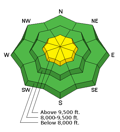
The majority of the terrain has a LOW avalanche danger today. There is a MODERATE avalanche danger along the highest and steepest terrain where recent wind drifted snow may be unstable still. Continue safe backcountry protocols by only putting one rider on a steep slope at a time and don't regroup at the bottom of avalanche paths.

Wind Drifted Snow


Description
None of the drifts that we poked at on Saturday were sensitive and we did not experience any cracking. They seem fairly stubborn at this point but I would use caution along the highest and steepest terrain where they have formed over the last few days.
Additional Information
It looks like a fairly nice day out today with some high clouds, mild temperatures and light wind. A ridge of high pressure will keep mild weather over our area for most of the week. The next chance for any snow accumulation looks like a small storm that might give us a little on Saturday.
General Announcements
We will publish full detailed advisories Saturday and Sunday mornings by 7am. We will also be publishing basic avalanche danger ratings & info during the week.
If you are getting out into the mountains, we love to hear from you! You can SUBMIT OBSERVATIONS ONLINE or EMAIL US
If you would like to have avalanche advisories emailed to you, SIGN UP HERE
We can provide basic avalanche awareness presentations for your school, group or club. To enquire, CLICK HERE