


Forecast for the Salt Lake Area Mountains

Saturday morning, January 28, 2017
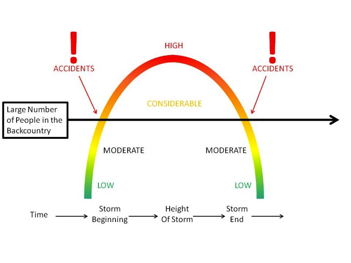
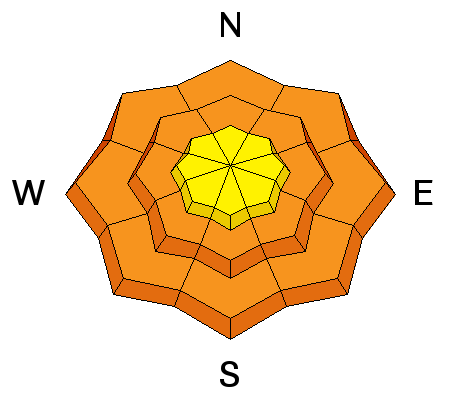
A CONSIDERABLE avalanche danger exists in the central Wasatch. Human triggered avalanches 2-3' deep are likely today on a variety of aspects and elevations. This weekend has accident written all over it: most of our accidents and fatalities occur under conditions like these. Remember that when you're accessing the backcountry from the mountain resorts, you're stepping into dangerous avalanche conditions.
 Special Announcements
Do you buy groceries at Smiths? Register your Smith’s rewards card with their Community Rewards program, and they will donate to the Utah Avalanche Center whenever you make a purchase. It's easy, only takes a minute, and doesn't cost you anything. Details
 Weather and Snow
Skies are clear. Under the tightening noose of a building ridge of high pressure, mountain temperatures are now at 24 hour highs in the mid teens. Gusty northerly winds continue to move snow and damage the open exposed terrain. They're still blowing 20-25mph with gusts to 30. 11,000' anemometers spin 35 mph with gusts to 50. Out of the wind and sun-zippered terrain, riding conditions remain superb, though a bit slow, on the recrystallizing snow surface and 1-2mm surface hoar from Thursday night.
Required Reading: Week in Review by Greg Gagne
Wow. A prolonged period of storms began late in the day on Friday Jan 20th, with an overachieving storm on Saturday the 21st with numerous human-triggered as well as natural avalanches occurring over the weekend. (Mark Staples described the activity of the weekend of Jan 21/22.)
Strong winds and heavy snowfall led to an avalanche warning issued by the UAC on Monday and Tuesday January 23/24 for the mountains of northern Utah. Little Cottonwood Canyon was closed beginning on Monday morning due to dangerous avalanche activity, and did not re-open until later Tuesday morning. Results from highway control work on several mountain roads in northern Utah produced large avalanches, with many hitting the road. A couple of Wasatch veterans reminded me that this is how "it used to be."
Throughout this extended period numerous natural and human triggered avalanches were reported on a variety of aspects and elevations, with several avalanches occurring at low elevations (< 9000'). Weaknesses included wind drifts, density changes within storm snow events, and persistent weak layers that formed during the spell of clear and cold weather from Jan 13 - 18, including both near-surface facets and surface hoar. Your pre-trip preparations should include reading field observations as well as recent avalanche activity from this past week. Bottom line - it was snowing and blowing for over a week, with storm snow falling on top of a weak, pre-existing snow surface at the mid and lower elevations, and it has led to a variable and complex snowpack.
Approximate storm and water totals since Jan 20 include:
LCC/BCC 80" 5.7"
Park City 44" 3.5"
Ogden 50" 2.5" - 3.5"
Provo 24" 2"
 Recent Avalanches
Requires a three part answer: persistent slabs, wind slabs, and minor wet loose point releases.
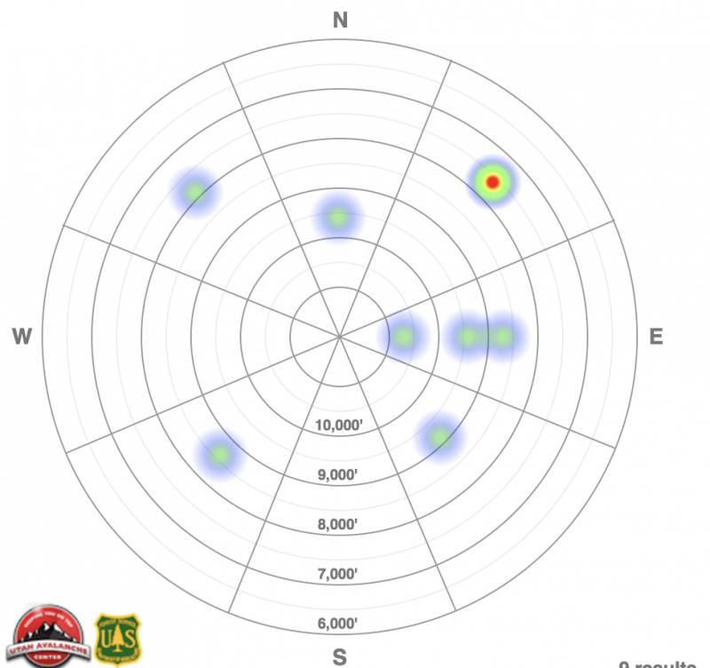
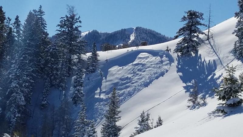
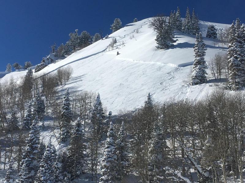
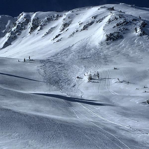
- Skiers triggered 6 separate persistent slabs 2-4' deep and generally 100' wide on north to east-southeast facing slopes yesterday. Elevations ranged from 7600'-9400'. This makes at least eight since Tuesday. All of these slides ran on either facets above a melt-freeze crust or surface hosr buried last Thursday January 19th under 50-90" of settling storm snow. Many of these slide were triggered remotely (at a distance) and caught and carried two skiers in separate events. The full list can be found here.
- With ramping north to northeast winds yesterday, a few sensitive natural and human triggered wind slabs occurred in high east to south facing terrain up to a foot deep.
- Minor wet loose point release sluffs peeled out of steep mid-elevation slopes with daytime heating.
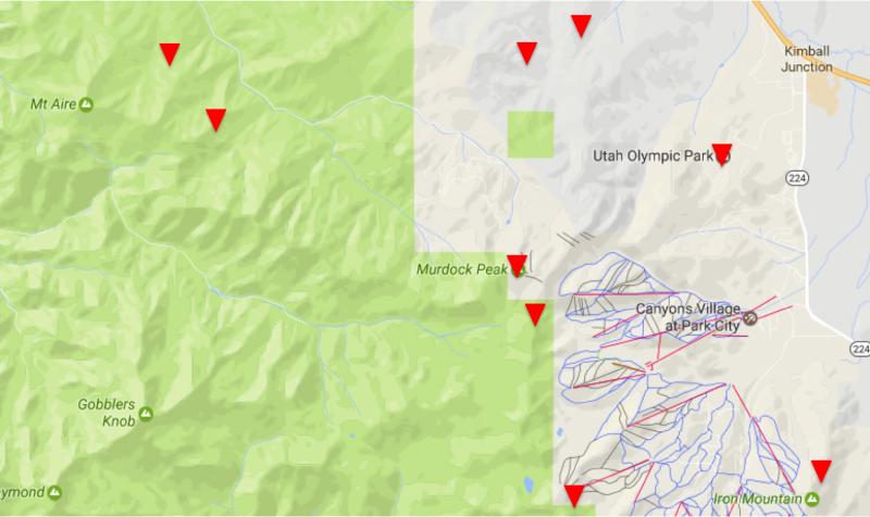
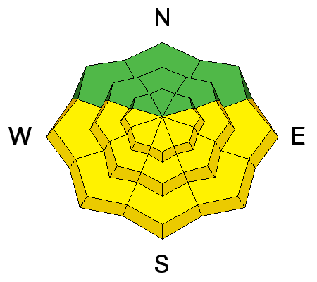
Evelyn created a map depicting locations for these recent human triggered persistent slabs. Note these have been on many aspects below 9500' and predominantly along the northern periphery of the Cottonwoods (Park City ridgeline, Summit Park, Mount Aire). Note that a couple of the wind slabs are included on the activity rose on the right - these account for the upper elevation slides. On another note, I was blown away by the number of people who submitted reports and observations yesterday- your information saves lives. Thank you.

Persistent Weak Layer
Description
Evidence based information: at least eight human triggered persistent slabs reported since Tuesday. Subtle to thunderous whoomphs and collapses noted as the storm snow collapses the weak surface hoar and facets that were not destroyed prior to last week's storm. Many of these triggered at a distance, fracturing out above the skier, or just adjacent to other tracks on the slope. The weakest and most suspect terrain is at the mid and low elevations on many aspects, but predominantly - but not all - on north to southeast facing slopes.
These are dangerous, unmanageable avalanches. See a couple photos below (Barker, Ellis). Click the 'i' next to the Persistent Slab icon for travel advice and more information on these types of avalanches.
You have three choices: roll the dice, do the homework, or stay off (and out from underneath) slopes approaching 35° and steeper.
- You roll the dice - you may get lucky, you may not. Remember these stakes are more than just money..and over time, the house always wins.
- Do the homework - pull out your shovel and look for the buried weaknesses to see if they're present and active. Extended column tests are useful. Then add a healthy dose of skepticism due to spatial variability.
- Terrain is your friend - plenty of good skiing and riding on low angle slopes out there.
Wind Drifted Snow
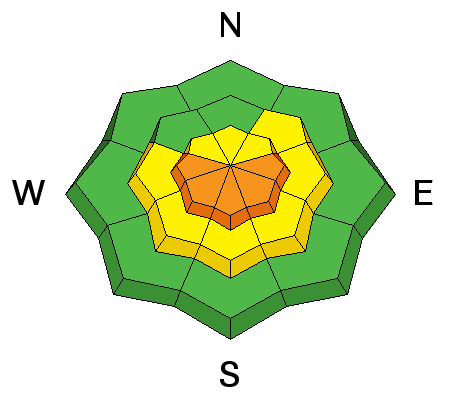
Description
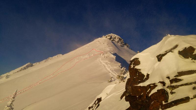
Fresh wind drifts. Gusty north-northwest to north-northeast winds fostered the development of 10-18" deep drifts along the higher exposed terrain yesterday and may have been particularly sensitive as they drifted on weak surface snow (1-1.5mm surface hoar and recrystallized snow). Naturals high along the Ivory Flakes along with human triggered slides on Superior and the high periphery south of Snowbird are representative of what you'll find today. See the Steve Achelis map for location details. These rounded drifts will still be sensitive to human provocation and may be triggered at a distance. The drifts will be more pronounced just to the lee of the exposed peaks and ridges. Sean Zimmerman Wall had a good observation in the Snowbird periphery. Photos White (Cardiac Ridge), Tuura (Little Superior).
Wet Snow
Description
Cold, dry snow under the heat lamp and with mountain temps rising into the mid 20s at 10,000' will conspire to dampen the snow surfaces on the steep sunlit slopes. With prolonged dampening, both natural and especially human triggered wet avalanches will be likely with daytime warming. Please choose terrain to avoid the steep sun-drenched slopes by midday - particularly those above roads and infrastructure. The danger may rise toward Considerable with extended warming....
Additional Information
Clear skies, moderate though gusty northerly winds, and temps rising to near freezing at 8500' today. High pressure builds throughout the region over the next few days.
General Announcements
|
Remember your information can save lives. If you see anything we should know about, please help us out by submitting snow and avalanche conditions. You can also call us at 801-524-5304, email by clicking HERE, or include #utavy in your tweet or Instagram. To get help in an emergency (to request a rescue) in the Wasatch, call 911. Be prepared to give your GPS coordinates or the run name. Dispatchers have a copy of the Wasatch Backcountry Ski map. Backcountry Emergencies. It outlines your step-by-step method in the event of a winter backcountry incident. If you trigger an avalanche in the backcountry, but no one is hurt and you do not need assistance, please notify the nearest ski area dispatch to avoid a needless response by rescue teams. Thanks.
EMAIL ADVISORY If you would like to get the daily advisory by email you will need to subscribe here. DAWN PATROL Hotline updated daily by 5-530am - 888-999-4019 option 8. TWITTER Updates for your mobile phone - DETAILS UDOT canyon closures: LINK TO UDOT, or on Twitter, follow @UDOTavy, @CanyonAlerts or @AltaCentral Utah Avalanche Center mobile app - Get your advisory on your iPhone along with great navigation and rescue tools. Powderbird Helicopter Skiing - Blog/itinerary for the day Lost or Found something in the backcountry? - http://nolofo.com/ To those skinning uphill at resorts: it is critical to know the resort policy on uphill travel. You can see the uphill travel policy for each resort here. Benefit the Utah Avalanche Center when you shop from Backcountry.com or REI: Click this link for Backcountry.com or this link to REI, shop, and they will donate a percent of your purchase price to the UAC. Both offer free shipping (with some conditions) so this costs you nothing! Benefit the Utah Avalanche Center when you buy or sell on ebay - set the Utah Avalanche Center as a favorite non-profit in your ebay account here and click on ebay gives when you buy or sell. You can choose to have your seller fees donated to the UAC, which doesn't cost you a penny. This information does not apply to developed ski areas or highways where avalanche control is normally done. This advisory is from the U.S.D.A. Forest Service, which is solely responsible for its content. This advisory describes general avalanche conditions and local variations always exist. |