Observation: Maybird Gulch

Observation Date
1/27/2017
Observer Name
Ryan
Region
Salt Lake » Little Cottonwood Canyon » Maybird Gulch
Location Name or Route
Red Pine and Maybird
Weather
Sky
Clear
Wind Direction
Northwest
Wind Speed
Strong
Weather Comments
Bluebird day, single digits to start and up to the low 20's during the middle of the day. Winds were calm down low, but blowing hard on the ridgeline. Streamers off the ridges were apparent when we started in the morning, and then were difficult to even stand up in when on the ridge later in the day.
Snow Characteristics
New Snow Depth
2'
New Snow Density
Low
Snow Surface Conditions
Powder
Wind Crust
Snow Characteristics Comments
Snow was variable from soft, fluffy power down low to dense wind jack up along the ridges. Lots of transport of the light upper few inches with the wind.
Red Flags
Red Flags
Recent Avalanches
Wind Loading
Red Flags Comments
We saw recent naturals in both upper Red Pine and upper Maybird, as well as upper Hogum (from a distance). Hard to tell when exactly they ran, since the wind was moving the new snow around and starting to fill in the old tracks. From the ridgeline, we could see lots of new wind loading on the south side of the Red Pine and Maybird ridgelines leading up to Pfeifferhorn.
Avalanche Problem #1
Problem
Wind Drifted Snow
Trend
Increasing Danger
Problem #1 Comments
We didn't test any of the south facing sides where the wind loading was occuring, but the pillows were obvious.
Avalanche Problem #2
Problem
Persistent Weak Layer
Trend
Decreasing Danger
Problem #2 Comments
Snowpack in the upper elevations of Red Pine and Maybird appears pretty stable. We experienced no collapsing, observed no cracking, and general found stable conditions. The recent slides we saw were probably naturals from several days ago, and the deeper instabilities seem to be healing well. We also dug a pit down lower in Red Pine (8,200') and got ECTN with no reaction (see profile below).
Snow Profile
Aspect
Northwest
Elevation
8,200'
Slope Angle
28°
Comments
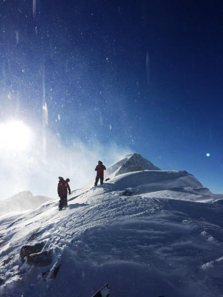
Travel was from White Pine TH, up/across Red Pine and into Maybird, up Maybird to the ridge below Pfeifferhon, then back out Red Pine. Pit was in west facing Red Pine, about 1/3 of the way along the trail after coming around from White Pine and heading toward the Maybird turnoff. F harness to about 1', then 4F below and 1F near the bottom of the pit (about 4'). Obvious density change about 2' down with some faceting (maybe this is the lower elevation surface hoar layer?), but we got no reaction with ECT. When we pried the column off with a shovel shear after ECT30, column had a Q2 to 2.5 shear just below this layer. Definitely a cohesive slab, but pretty nonreactive. We were not very concerned at this location. Did not observe this same structure up higher (above ~9,700')...maybe the surface hoar layer never established up high? Winds were nuking on the ridgeline with a significant amount of transport (see photo of Pfeiff summit with streamers off it...our plan was to summit, but we bailed due to the winds). Wind slabs are going to be an issue for a little while.
Today's Observed Danger Rating
Moderate
Tomorrows Estimated Danger Rating
Considerable