Forecast for the Moab Area Mountains

Eric Trenbeath
Issued by Eric Trenbeath for
Thursday, January 26, 2017

The avalanche danger is CONSIDERABLE on all aspects in upper elevation, wind drifted terrain and human triggered avalanches are likely in these areas. At mid and lower elevations the danger remains CONSIDERABLE on steep slopes that face NW-N-SE. The danger is MODERATE on mid and low elevation terrain on slopes that face S-W.

Low
Moderate
Considerable
High
Extreme
Learn how to read the forecast here
Special Announcements


Support the Utah Avalanche Center just by buying groceries!

Do you buy groceries at City Market? When you register your Kroger rewards card with their Community Rewards program, they will donate to the Utah Avalanche Center whenever you make a purchase. It's easy, only takes a minute, and doesn't cost you anything. Details here.

Road Conditions: Grand County pushed through one lane up to the trailhead on Monday and the road is passable.

Backcountry 101 Avalanche Class

We will be offering a Backcountry 101 avalanche class on Feb 3, 4. This course will include a night classroom session and a day in the field. Cost is $125 with proceeds to benefit the Utah Avalanche Center Moab. For more information or to sign up go here.

Weather and Snow

Heavy snowfall and strong winds have created areas of deep drifted snow, alternating with scoured zones and thick wind crusts. All told, the mountains have received 40" of snow above 10,000' since last Thursday night. Winds on Monday averaged 30-40 mph for several hours with regular gusts over 70. Use the links below for current wind, snow totals, and temperature.

Wind, temperature and humidity on Pre Laurel Peak.(11,700')

Storm totals and temperature in Gold Basin.(10,000')

Snow totals, temperature and snow/water equivalent at the Geyser Pass Trailhead. (9600')

Recent Avalanches

On Saturday, a party remotely triggered this avalanche on a north facing slope at 10,400'. The avalanche likely failed on buried near surface facets under the load of new storm snow, eventually stepping down to deeper faceted layers around rocks.


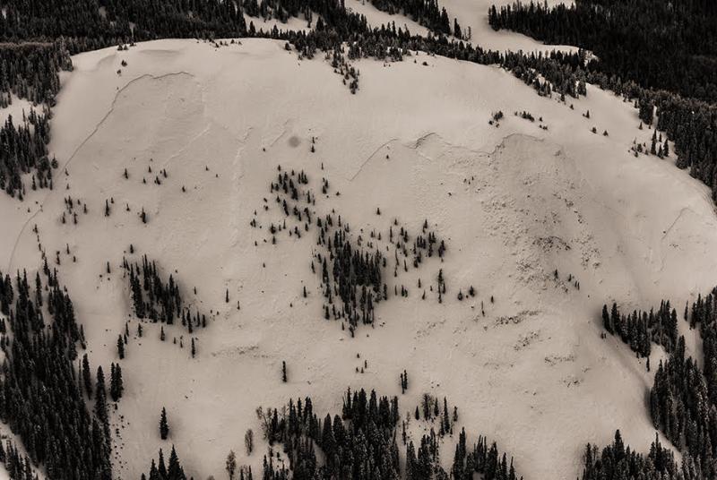
Photo courtesy of James "Jimbo" Collins who was out flying around.

Ad
Avalanche Problem #1
Wind Drifted Snow
Type
Location
Likelihood
Size
Description

Strong winds and heavy snowfall, have caused deep wind slabs to form on the lee sides of ridge crests and terrain features. The danger will be greatest on slopes facing the north half of the compass, but with so much snow blowing around, wind slabs will have formed on all aspects wherever terrain features are able to capture drifting snow.

Avalanche Problem #2
Persistent Weak Layer
Type
Location
Likelihood
Size
Description

Heavy snowfall and wind loading have increased the stress on buried weak layers within the snowpack. Avalanches initiated within the new snow now have the potential to step down into these buried weak layers. In some cases this could mean stepping down to buried near surface facets that formed prior to the beginning of this last storm cycle. In other cases, it could mean stepping down to weak, faceted snow near the ground.

Additional Information

Thursday

A 20 percent chance of snow showers. Partly sunny, with a high near 19. Northwest wind around 5 mph.

Thursday Night

Partly cloudy, with a low around 5. North wind 5 to 10 mph.

Friday

Sunny, with a high near 22. North northeast wind around 10 mph.

General Announcements

If you are getting out into the mountains, we love to hear from you! You can SUBMIT OBSERVATIONS ONLINE

If you would like to have avalanche advisories emailed to you, SIGN UP HERE

Benefit the Utah Avalanche Center when you shop from Backcountry.com or REI: Click this link for Backcountry.com or this link to REI, shop, and they will donate a percent of your purchase price to the UAC. Both offer free shipping (with some conditions) so this costs you nothing!

The information in this advisory is from the US Forest Service which is solely responsible for its content. This advisory describes general avalanche conditions and local variations always occur.