

Forecast for the Uintas Area Mountains

Tuesday morning, January 24, 2017
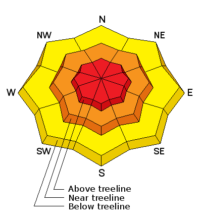
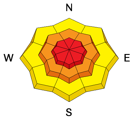
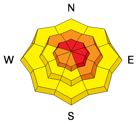
In the wind zone, at and above treeline, the avalanche danger is HIGH. Both human triggered and natural avalanches are VERY LIKELY on steep, wind drifted slopes, especially those on the leeward side of upper elevation ridges and particularly those with an easterly component to their aspect. Remember- any avalanche that breaks to weaker snow, now buried deep in the snowpack will get out of hand quickly, resulting in a dangerous slide.
A CONSIDERABLE avalanche danger is found in mid elevation terrain and human triggered avalanches are LIKELY on steep slopes with recent deposits of wind drifted snow.
Even steep, lower elevation terrain is getting in on the act. A MODERATE avalanche danger exists and human triggered avalanches are POSSIBLE on steep, wind drifted slopes.
Avalanche Warning
THE FOREST SERVICE UTAH AVALANCHE CENTER IN SALT LAKE CITY HAS ISSUED A BACKCOUNTRY AVALANCHE WARNING.
* TIMING...IN EFFECT THROUGH 6AM WEDNESDAY.
* AFFECTED AREA...FOR THE MOUNTAINS OF NORTHERN UTAH INCLUDING THE WASATCH RANGE...BEAR RIVER RANGE...THE MOUNTAINS OF SOUTHEAST IDAHO... AND THE WESTERN UINTAS
* AVALANCHE DANGER...HIGH.
* REASON/IMPACTS...HEAVY DENSE SNOW COMBINED WITH STRONG WINDS HAS CREATED WIDESPREAD AREAS OF UNSTABLE SNOW AT ALL ELEVATIONS INCLUDING LOW ELEVATION TERRAIN. BOTH HUMAN TRIGGERED AND NATURAL AVALANCHES ARE LIKELY. STAY OFF OF AND OUT FROM UNDER SLOPES STEEPER THAN 30 DEGREES.
 Special Announcements
Wednesday- January 25th 6:00 PM. I'll be giving a FREE avalanche awareness presentation at Cycle City in Evanston. I'll address sled specific avalanche concerns as well as current conditions. To reserve a seat, please RSVP at 307- 789-7533... operators are standing by :)
 Weather and Snow
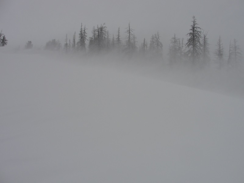
The recent parade of overachieving storms marched into the western Uinta's early yesterday morning, quickly stacking up and evenly distributed two feet of medium density snow across the range. Under mostly cloudy skies, a flurry or two is still in the air and temperatures are in the teens and single digits. Winds finally relaxed last night, switched to the west and northwest and are currently blowing 15-25 mph along the high ridges. Our big open bowls have taken a hard hit from the wind, but you'll find excellent riding and turning conditions on low elevation, wind sheltered, shady slopes.
Snowpack observations and trip reports are found here.
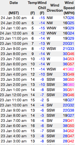
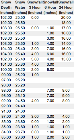
On the left a 24 hour run of the Windy Peak weather station. On the right, Trial Lake reflecting just over 2' of snow and 2.2" of H20!
Real time wind, snow, and temperatures for the Uinta's are found here
 Recent Avalanches
Very sensitive slabs formed at all elevations and they were reactive to the additional weight of a person, breaking several feet deep yesterday. A full list of Uinta avalanche activity is found here. (Boyer photo)

Wind Drifted Snow
Description
Winds cranked at all elevations yesterday and there's no shortage of snow available to blow around and form drifts sensitive to our additional weight. The good news is... today's slabs might not be quite as sensitive as yesterday. The bad news is... they'll allow us to get further out on the slope before they fail. In either case, make no mistake, today's avalanches are the real deal. Once triggered they'll break several feet deep, they're gonna be connected, and at the very least, they'll ruin your day if you're on the receiving end. It doesn't mean you can't ride. It does mean you need to stay off of and out from under steep, wind drifted slopes.
During the height of the storm winds were wailing along the mid and upper elevation ridges. (Janulaitis photo)
Persistent Weak Layer
Description
There are several weak layers of snow now buried a couple feet deep in our snowpack and the additional weight of the recent storms is gonna bring these dormant layers back to life. While many slopes avalanched naturally during the storm, there's still plenty more that just need a trigger like us to come along and knock the legs out from underneath them. Any avalanche that breaks into weak layers buried deep in the snowpack will be dangerous. But the solution for the next couple of days is easy. Simply avoid being on, under, or connected to steep, wind drifted slopes, especially those facing the north half of the compass and particularly those with an easterly component to their aspect.
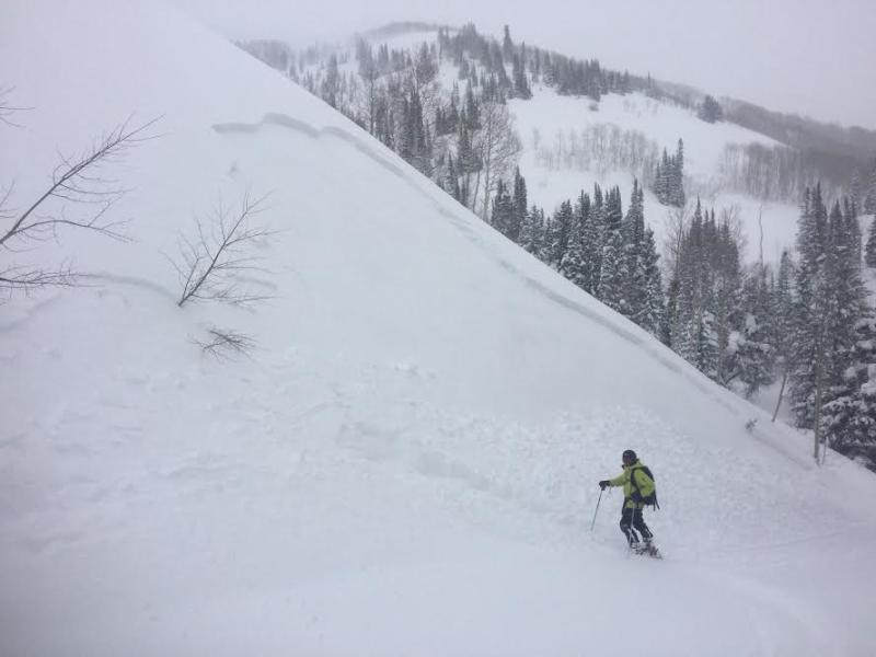
Steep, complex terrain like Gold Hill is the kind of place you could trigger a deep, dangerous avalanche. (T. Scroggin photo)
Additional Information
Snow showers increase this afternoon with another couple inches expected. High temperatures reach into the 20's with overnight lows in the single digits. West and northwest winds remain behaved and blow in the mid 20's and low 30's along the ridges. A similar day is on tap for tomorrow. We dry out later this week and a strong warming trend is expected Friday into next week as a ridge dominates the weather pattern.
General Announcements
Remember your information can save lives. If you see anything we should know about, please participate in the creation of our own community avalanche advisory by submitting snow and avalanche conditions. You can call me directly at 801-231-2170, email [email protected]
The information in this advisory is from the US Forest Service which is solely responsible for its content. This advisory describes general avalanche conditions and local variations always occur.
The information in this advisory expires 24 hours after the date and time posted, but will be updated by 7:00 AM on Wednesday January 25th.