Forecast for the Skyline Area Mountains

Brett Kobernik
Issued by Brett Kobernik on
Saturday morning, January 21, 2017

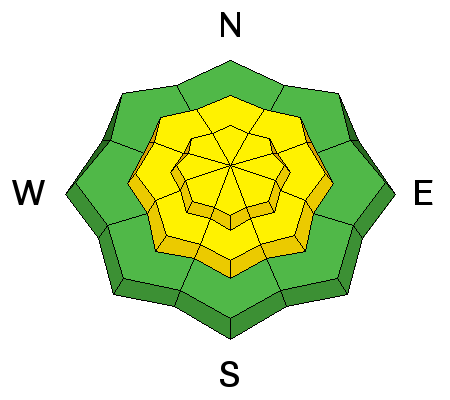
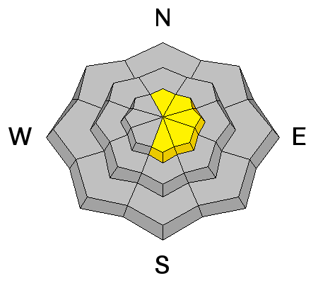
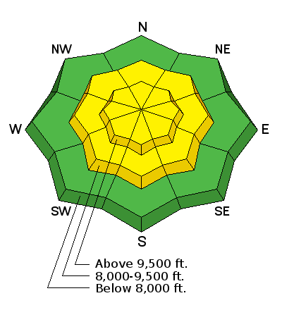
The avalanche danger is MODERATE in the mid and upper elevation terrain on slopes steeper than 35 degrees. Human triggered avalanches are possible. The danger may rise to CONSIDERABLE if we receive more snow than I'm anticipating. Watch for cracking during your travel and avoid bigger steep slopes if you are seeing lots of shooting cracks.

Low
Moderate
Considerable
High
Extreme
Learn how to read the forecast here
Special Announcements

If you sign up for AmazonSmile and designate the Utah Avalanche Center as your favorite charity, they will donate a portion of everything you spend to the UAC. It doesn't cost you a penny and we'd really appreciate the help.

Weather and Snow

2 to 4 inches of snow fell Thursday afternoon and night. There was some riming that occurred during the day on Thursday which we noted while it was coating our glasses and goggles during the ride. You will notice a thin rime crust under the new snow. Overall, the snowpack is well consolidated and stable. At the end of the day on Friday the wind increased a bit and was starting to transport snow into drifts. We noted slight cracking in the wind drifted areas. Steve and Darce noted similar conditions on their travels which can be found HERE.

Not much snow accumulated overnight. Ridgetop wind is from the southeast in the light to moderate speed category. Temperatures are in the low 20s.

Ad
Avalanche Problem #1
New Snow
Type
Location
Likelihood
Size
Description

The main concern today is the potential for human triggered avalanches within the newer snow. We may see some failure around the buried rime crust from Thursday. We may also see some weakness under freshly formed wind drifts. These problems most likely will not be long lasting concerns but we will want to pay close attention during the current storm and the next storm expected on Sunday night.

Avalanche Problem #2
Wind Drifted Snow
Type
Location
Likelihood
Size
Description

As the wind shifts to the northwest mid day and increases in speed, we will probably see some fresh sensitive drifts form. Avoid areas where wind is rapidly depositing snow along the upper ridgelines.

Additional Information

We should see snow during the day today. I'm anticipating 4 to 6 inches of snow. Ridgetop wind is going to shift to the northwest mid day and increase in speed somewhat. Temperatures will remain in the low 20s. We'll see cloudy skies on Sunday with light southerly wind and high temperatures in the mid 20s. A larger storm starts moving in late Sunday and will last into Tuesday with stronger wind. This could produce a foot of snow or so along the Manti Skyline.

General Announcements

We will publish full detailed advisories Saturday and Sunday mornings by 7am. We will also be publishing basic avalanche danger ratings & info during the week.

If you are getting out into the mountains, we love to hear from you! You can SUBMIT OBSERVATIONS ONLINE or EMAIL US

If you would like to have avalanche advisories emailed to you, SIGN UP HERE

We can provide basic avalanche awareness presentations for your school, group or club. To enquire, CLICK HERE