Forecast for the Abajo Area Mountains

Eric Trenbeath
Issued by Eric Trenbeath for
Tuesday, January 17, 2017

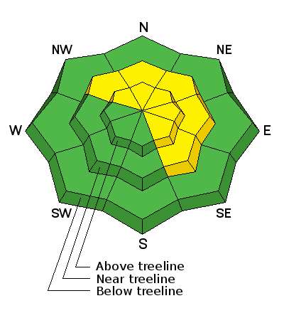
The avalanche danger is MODERATE on steep, upper-mid to upper elevation slopes that face the north half of the compass. Watch for areas of wind drifted snow on the lee sides of ridge crests and terrain features, such as gully walls and rock outcrops. It is possible that an avalanche triggered in these areas could fail on weak, sugary snow near the ground. Out of the wind zone and at lower elevations the danger is mostly LOW.

Low
Moderate
Considerable
High
Extreme
Learn how to read the forecast here
Special Announcements

The Abajo/Blue Mountain avalanche advisory will provide detailed information on the weekends. During the week, general information and a danger rating will be posted.

Weather and Snow

About a foot of new snow trickled in to the Abajo/Blue Mountains last week and conditions have significantly improved. Wind exposed slopes are still showing some grass, but leeward and sheltered areas are filling in and snow depths now range from 2-4' at mid and upper elevations.

For real time weather data click on the links below:

Winds, temperature and humidity on Abajo Peak.

Snow totals at Camp Jackson.

Additional Information

Drier weather will begin to take over the area through mid week with a more active pattern returning by Thursday.

Abajo/Blue Mountains weather forecast.