Forecast for the Moab Area Mountains

Eric Trenbeath
Issued by Eric Trenbeath for
Monday, January 9, 2017

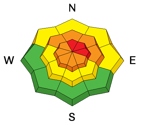
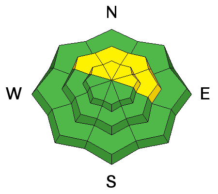
The avalanche danger will rise to CONSIDERABLE today as strong winds and blowing snow create dangerous avalanche conditions in steep, wind exposed terrain. Avoid slopes steeper than about 30 degrees that have recent deposits of wind drifted snow, and stay out from under large run out zones, particularly those that face N-NE-E. The avalanche danger could reach HIGH in these areas by later this afternoon.

Low
Moderate
Considerable
High
Extreme
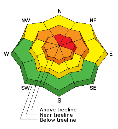
Learn how to read the forecast here
Special Announcements

Backcountry 101 Avalanche Course

We will be offering a Backcountry 101 avalanche class on Feb 3, 4. This course will include a night classroom session and a day in the field. Cost is $125 with proceeds to benefit the Utah Avalanche Center Moab. For more information or to sign up go here.

Grand County Search and Rescue and the Winter Rescue Team conduct joint training.

GCSAR and WRT held a joint training session on Saturday above the Geyser Pass Trailhead. Thanks to everyone who turned out, and a big shout out to ex Alta ski patroller Scott Sole for lending his expertise. It's a crack group who have proved their skills time and time again. We are fortunate to have such a resource here in our little mountain range.


Scott Sole explains the finer points of avalanche rescue. (photo by Bego Gerhart)


Team members engage in probe line practice. (photo by Bego Gerhart)

Weather and Snow

Gold Basin has received 4" of snow in the past 24 hours, and only an inch or so has fallen at the Geyser Pass Trailhead. But the real story today is going to be the wind! The relentless 20-30 mph southwest bluster that has been been hammering peaks and transporting snow all week will get a dramatic surge today. Ridge top averages will be in the 40-50 mph range with gusts into the 80's! This alone will be enough to raise the avalanche danger. Add forecasted snow totals of 5-10" and it could get dicey out there. Best bet today will be to stick to low angle, wind sheltered terrain. It's currently a very warm 35 degrees at the Geyser Pass Trailhead and 24 on Pre Laurel Peak.

Observations have streamed in over the weekend. I really appreciate it and it's great to know so many local folks are out and about and staying on top of conditions. It's a great community! For a full list of recent observations go here.

Base depth in Gold Basin: 50" Snow overnight: 2" 24 hour snow: 4" Season total: 124" Percentage of normal: 169%

Storm totals and temperature in Gold Basin.(10,000')

Wind, temperature and humidity on Pre Laurel Peak.(11,700')

Snow totals, temperature and snow/water equivalent at the Geyser Pass Trailhead. (9600')

Wind exposed, south and west facing slopes have taken a hit, especially above tree line. Best bet for good snow is to seek out sheltered locations. (photo by Reed Kennard) A report of his travels can be found here.

Ad
Avalanche Problem #1
Wind Drifted Snow
Type
Location
Likelihood
Size
Description

Strong winds with plenty of available snow for transport spell one thing - wind slab danger. Today you will be need to be alert to rapidly changing conditions, and continually be on the lookout for newly formed deposits of wind drifted snow. The strong winds will deposit snow further down slope than is usual. Suspect smooth rounded pillows and look for cracking in the snow surface. Avoid slopes steeper than about 30 degrees where wind loading has occurred. The danger will be most acute on upper elevation slopes that face N-NE-E, but with winds of this intensity cross loading will be a factor and you may encounter wind slabs on all aspects.

Avalanche Problem #2
Persistent Weak Layer
Type
Location
Likelihood
Size
Description

Our snowpack still contains a few weak layers. In most cases these layers are not proving to be reactive, and the chances of triggering a deep and dangerous, persistent slab are growing less likely. However, isolated areas remain, and I received this report from Brian Sparks yesterday who turned off from a NE facing slope right around tree line due to a collapse, and the presence of a weak layer that propagated under an extended column test. Steep, upper mid-upper to upper elevation slopes facing the north half of the compass are still a little suspicious. Wind loading today will put many of these slopes to the test.

This Dave Garcia photo illustrates a weak layer of concern. Taken on Wednesday, up to 10" of new snow, or more if drifted, now sits on top of the old snow surface.

Additional Information

An "atmospheric river" is poised to deliver moisture throughout the region for the upcoming week. Heavy snow and very strong southwest winds are in the forecast today.

Today

Snow. High near 31. Very windy, with a southwest wind 45 to 55 mph, with gusts as high as 80 mph. Chance of precipitation is 100%. Total daytime snow accumulation of 6 to 10 inches possible.

Tonight

Snow, mainly before 4am. Low around 17. Very windy, with a west southwest wind 35 to 45 mph decreasing to 25 to 35 mph after midnight. Winds could gust as high as 70 mph. Chance of precipitation is 80%. New snow accumulation of 3 to 7 inches possible.

Tuesday

A 50 percent chance of snow. Mostly cloudy, with a high near 25. Breezy, with a west southwest wind 15 to 20 mph, with gusts as high as 35 mph. New snow accumulation of less than one inch possible.

Tuesday Night

Snow likely, mainly after 11pm. Cloudy, with a low around 19. Breezy, with a southwest wind around 25 mph, with gusts as high as 35 mph. Chance of precipitation is 60%. New snow accumulation of 2 to 4 inches possible.

Wednesday

Snow. High near 25. Breezy, with a southwest wind around 25 mph, with gusts as high as 40 mph. Chance of precipitation is 80%.

General Announcements

Road Conditions: Expect to find accumulating and drifting snow on the road today at the upper end..

Grooming: Matt and Travis groomed all of the trails on Saturday.

If you are getting out into the mountains, we love to hear from you! You can SUBMIT OBSERVATIONS ONLINE

If you would like to have avalanche advisories emailed to you, SIGN UP HERE

Benefit the Utah Avalanche Center when you shop from Backcountry.com or REI: Click this link for Backcountry.com or this link to REI, shop, and they will donate a percent of your purchase price to the UAC. Both offer free shipping (with some conditions) so this costs you nothing!

Benefit the Utah Avalanche Center when you buy or sell on ebay - set the Utah Avalanche Center as a favorite non-profit in your ebay account here and click on ebay gives when you buy or sell. You can choose to have your seller fees donated to the UAC, which doesn't cost you a penny.

The information in this advisory is from the US Forest Service which is solely responsible for its content. This advisory describes general avalanche conditions and local variations always occur.