

Forecast for the Salt Lake Area Mountains

Friday morning, December 30, 2016
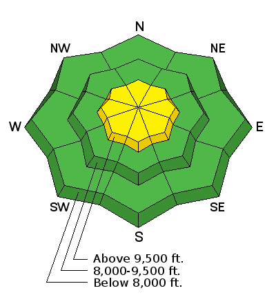
The avalanche hazard is Low at low and mid elevations. At upper elevations, there exists a Moderate hazard of triggering a wind slab or persistent deep slab. Wet activity is possible on steep sunny aspects as well as lower elevations.
 Special Announcements
Congratulations to Aaron Rice who on Thursday completed his year-long mission of skiing 2.5 million vertical feet of human-powered travel. A remarkable achievement indeed. Congratulations Aaron!
The National Avalanche Center just released this new video on the avalanche problems and how they work. This is a key aspect to mountain travel. Understanding what type of avalanche you're dealing with.
 Weather and Snow
Skies are clear this morning and there is a temperature inversion with canyon bottoms in the mid 20's, and upper elevations just below freezing. Winds are generally light and westerly, with some upper elevation anemometers gusting in the mid 20's mph.
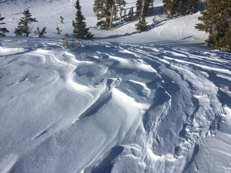
Finding soft, untracked snow is becoming increasingly difficult. Southeast through west aspects dampened on Thursday and will be crusted this morning. Much terrain in the alpine, as well as open terrain in mid elevations, is either wind eroded or wind crusted. However, if you search, soft recrystallized snow can be found in wind and sun sheltered mid elevations providing enjoyable riding conditions.
Week in Review
Snow totals from the Christmas storm in the Salt Lake and Park City mountains ranged from 10-26" with about 2" water weight. The Provo mountains received about half that amount. The big winner was the northern Wasatch with the Ogden area mountains receiving 15-30" and 2.5" of water.
The Christmas storm wound down by late Sunday night, with Monday featuring cold, clear weather and 5-star ski conditions. Winds began to blow on Tuesday and Wednesday, and generally out of the west. There was some limited avalanche activity reported from the backcountry consisting of fresh wind slabs, but most observers on Thursday reported the recent wind slabs to be stubborn and unreactive to stability tests. Thursday featured warm and clear weather with light winds.
 Recent Avalanches
No activity was reported from the backcountry on Thursday other than wet, rollerballs as the sun warmed the snow surface on solar aspects. Control work from explosive testing at some Cottonwood resorts reported class 2 avalanches (large enough to bury as person) consisting of recent wind slabs.
Normal Caution
Description
The avalanche hazard is generally Low, however there are three current avalanche concerns which lead to a Moderate hazard in the upper elevations:
1. Wind Slabs. There are hard wind slabs in the mid and upper elevations that formed from the persistent winds on Tuesday and Wednesday. Backcountry observers on Thursday reported these slabs to be unresponsive to stability tests - at most only cracking right around your skis - and they should continue to stabilize today. However, these slabs are sitting on top of softer, lower density snow which can provide the necessary weak layer to triggering a wind slab avalanche. Triggering wind slab avalanches is unlikely today, and if you do, they would be mostly 4-12" deep pockets and not well-connected. Wind slabs in exposed, upper elevation terrain may be larger and more connected.
2. Persistent Slabs. Based upon field observations, our persistent, deep slab avalanche problem is currently dormant. But in some terrain on upper elevation, northerly aspects, weak snow sits at the base with a stronger slab on top. In addition to the snow from the Christmas storm, some of these upper elevation slopes have also undergone recent wind loading this past week. Although the persistent, deep slab problem is very isolated, any avalanche breaking down near the ground in this type of terrain would be very large and dangerous. Remember, with a persistent slab instability, tracks on a slope are not an indication of stability!
3. Wet Activity. Skies were clear and temperatures were quite warm on Thursday with observers noting roller balls on solar aspects by late morning, and steep south faces dampening by mid-day. I am not expecting an increase in wet activity for today as temperatures are forecasted to be slightly lower than Thursday, along with a possible increase in cloud cover later in the day. And although it's hard to believe we are talking about wet activity in late December, southeast through west aspects will warm again today with wet rollerballs beginning by late morning. With a decent low elevation snowpack, by early afternoon loose wet activity as well as wet slabs in lower elevations is also possible. If you find the snow surface dampening, you may want to reconsider plans for steep, lower elevation exits such as Maybird Gulch.
As always, be sure to practice safe travel protocols and ski a slope one at a time and get out of the runout zone at the bottom of a slope.
Additional Information
8000' temperatures will reach the upper 30's, and just below freezing at 10,000'. Winds will be out of the west and southwest and generally light, with ridgelines averaging in the teens with gusts in the 20's. Weather looks more promising by late this weekend with cooler temperatures and unsettled weather expected through much of this upcoming week.
General Announcements
|
Remember your information can save lives. If you see anything we should know about, please help us out by submitting snow and avalanche conditions. You can also call us at 801-524-5304, email by clicking HERE, or include #utavy in your tweet or Instagram. To get help in an emergency (to request a rescue) in the Wasatch, call 911. Be prepared to give your GPS coordinates or the run name. Dispatchers have a copy of the Wasatch Backcountry Ski map. Backcountry Emergencies. It outlines your step-by-step method in the event of a winter backcountry incident. If you trigger an avalanche in the backcountry, but no one is hurt and you do not need assistance, please notify the nearest ski area dispatch to avoid a needless response by rescue teams. Thanks.
EMAIL ADVISORY If you would like to get the daily advisory by email you will need to subscribe here. DAWN PATROL Hotline updated daily by 5-530am - 888-999-4019 option 8. TWITTER Updates for your mobile phone - DETAILS UDOT canyon closures: LINK TO UDOT, or on Twitter, follow @UDOTavy, @CanyonAlerts or @AltaCentral Utah Avalanche Center mobile app - Get your advisory on your iPhone along with great navigation and rescue tools. Powderbird Helicopter Skiing - Blog/itinerary for the day Lost or Found something in the backcountry? - http://nolofo.com/ To those skinning uphill at resorts: it is critical to know the resort policy on uphill travel. You can see the uphill travel policy for each resort here. Benefit the Utah Avalanche Center when you shop from Backcountry.com or REI: Click this link for Backcountry.com or this link to REI, shop, and they will donate a percent of your purchase price to the UAC. Both offer free shipping (with some conditions) so this costs you nothing! Benefit the Utah Avalanche Center when you buy or sell on ebay - set the Utah Avalanche Center as a favorite non-profit in your ebay account here and click on ebay gives when you buy or sell. You can choose to have your seller fees donated to the UAC, which doesn't cost you a penny. This information does not apply to developed ski areas or highways where avalanche control is normally done. This advisory is from the U.S.D.A. Forest Service, which is solely responsible for its content. This advisory describes general avalanche conditions and local variations always exist. |