

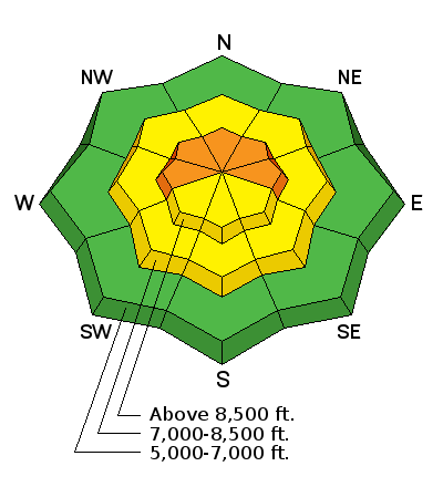
Forecast for the Logan Area Mountains

Tuesday morning, December 27, 2016
South winds increased significantly overnight, and dangerous avalanche conditions exist on drifted slopes at upper elevations. Fine powder conditions and mostly stable snow can be found in lower angled, lower elevation, and sheltered terrain. Careful snowpack evaluation, cautious route-finding and conservative decision making are essential at upper elevations today.
 Special Announcements
Come join us January 5 and 7 for an avalanche awareness class in Logan. We'll spend Thursday evening in the classroom and then Saturday in the field. You'll learn about avalanche rescue techniques, safe travel protocol and terrain management. This year is shaping up to be a good one so treat yourself to the gift of knowledge. It may just save your life. Register online at the link below.
https://utahavalanchecenter.org/classes/avalanche-awareness-class-logan-0
 Weather and Snow
The Tony Grove Snotel at 8400' reports 14 degrees and 51" of total snow containing 114% of average SWE for the date. The Christmas storm brought about a foot of new snow to the central and northern parts of the Bear River Range. Significantly more new snow fell in Cache Valley, the Front Canyons, the Wellsville Range, and the southern Bear River Range. It's 5 degrees at the CSI Logan Peak weather station at 9700', and south winds increased significantly overnight. The wind sensor currently shows sustained wind speeds of 35 mph, with gusts to 50 mph. Drifting snow has created dangerous avalanche conditions at upper elevations in exposed terrain, but fine powder riding conditions exist on lower angled slopes in sheltered areas and lower and mid elevations. South facing slopes at mid and lower elevations have developed a thin sun-crust.
 Recent Avalanches
Reported avalanche activity in the Logan Zone from Boxing Day, 12-26-16:
- An observer reported a natural cycle during the Christmas storm in the mountains above Paradise. The avalanches on east facing slopes just below 8000' in elevation, were 2' deep and 60' wide, failing on near surface facets/surface hoar above the 12/16 rain-crust.
- Riders in the Tony Grove Area triggered a few shallow soft slabs involving the new snow. Debris from one piled up deeply in a gully below the short slope.
- Skiers in the Garden City Bowls Area also triggered a few sensitive soft slabs, 8" to 10" deep and around 50' wide. These occurred on mid-elevation rolls in low angled northeast facing terrain on slopes less than 35 degrees, indicating likely failure on surface hoar. One skier was caught, but managed to ski out of it before being carried.

-
A shallow remote-triggered soft slab avalanche in the Garden City Bowls. (12-26-16)

Wind Drifted Snow
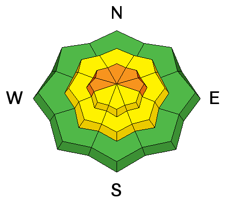
Description
Drifting snow from an overnight increase in south winds has created dangerous wind slab avalanche conditions in exposed upper elevation terrain. This morning the increasing wind is picking up lots of very light new snow in upper elevation fetch zones and depositing it in stiffer wind slabs on the lee side of ridges and around terrain features. Slabs are forming on last week's weak snow and will be sensitive to human triggering.
- Fresh wind slabs are rounded and chalky and produce hollow, drum-like sounds.
- Avoid drifted snow on the lee side of ridges and in and around terrain features like gullies, scoops, sub-ridges, and cliff-bands.
Persistent Weak Layer
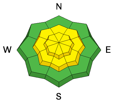
Description
- Some areas have buried weak surface snow made up of surface hoar and/or near surface facets. Avalanches failing on surface hoar sometimes occur on low angled slopes, and many experienced riders have been fooled by this tendency.
- Weak layers of small-grained near surface facets exist above and below rain-crusts at mid and lower elevations, and triggered avalanches stepping into old snow are possible in some areas.
- Although becoming unlikely with time and increasing snow depth, deep slab avalanches, failing on weak faceted snow or depth hoar near the ground are still possible, especially on upper elevation north facing slopes.
Additional Information
A storm system to our north will graze the mountains of Northern Utah tonight, bringing an increase in west winds and a chance for a few inches of snow. Expect breezy conditions and drifting snow at upper elevations today, with a high temperature at 8500' around 18 degrees and sub zero wind chills. West winds will increase tonight, temperatures will remain steady at 15 degrees F, with 3" to 5" of new snow possible. Snow should continue into Wednesday, with a couple more inches possible, breezy northwest wind, and continued cold temperatures. A weak and short-lived high pressure system will build over the area later in the week, and unsettled weather is expected for the weekend.
General Announcements
The early season is a great time to practice companion rescue techniques with your partners. Companion Rescue Practice Video
Discount lift tickets for Beaver Mountain, Snowbasin, Powder Mountain, and the Central Wasatch resorts are donated by the resorts to benefit the Utah Avalanche Center. Details and order information here.
Check out Avalanche Canada's "Rescue at Cherry Bowl" story HERE
Between now and Jan 15th: Donate to the Utah Avalanche Center by shopping at Whole Foods Market Utah! When you visit any Utah Whole Foods Market locations, bring your re-usable bags, Whole Foods will donate a dime per bag to the Utah Avalanche Center - if you say DONATE my bag credit.
We will update this advisory regularly on Monday, Wednesday, Friday, and Saturday mornings by about 7:30.
Your information can save lives. If you see anything we should know please help us out by submitting snow and avalanche observations. You can call us at 801-524-5304, email by clicking HERE, or include @utavy in your Instagram. In the Logan Area you can reach me at 435-757-7578
This advisory is from the U.S.D.A. Forest Service, which is solely responsible for its content. This advisory describes general avalanche conditions and local variations always exist.