Forecast for the Ogden Area Mountains

Paige Pagnucco
Issued by Paige Pagnucco for
Friday, December 16, 2016

The avalanche danger is HIGH today in the Ogden mountains. The strong winds and high precipitation rates have created very dangerous avalanche conditions and travel in avalanche terrain is not recommended.

Avoid slopes steeper than 30 degrees as well as locally connected terrain. Avalanche danger will remain elevated throughout the day as a strong storm affects the area.

With warm temperatures and rain at lower elevations, loose wet snow avalanches are possible in steep terrain. Pay attention to what's above and around you.

If you are looking to ride the steeps, today is a great day to head to one of your local resorts.

Low
Moderate
Considerable
High
Extreme
Learn how to read the forecast here
Avalanche Warning

THE FOREST SERVICE UTAH AVALANCHE CENTER IN SALT LAKE CITY HAS ISSUED A BACKCOUNTRY AVALANCHE WARNING.

* TIMING…IN EFFECT FROM 6 AM MST THIS MORNING TO 6 AM SATURDAY MORNING

* AFFECTED AREA…FOR THE MOUNTAINS OF NORTHERN AND CENTRAL UTAH INCLUDING THE WASATCH RANGE...BEAR RIVER RANGE...WESTERN UINTA...AND MANTI SKYLINE MOUNTAINS.

* AVALANCHE DANGER…THE AVALANCHE DANGER FOR THE WARNING AREA IS HIGH AND WILL REMAIN HIGH THROUGH SATURDAY.

* IMPACTS…HEAVY SNOW, MOUNTAIN RAIN AND STRONG WINDS HAVE CREATED WIDESPREAD AREAS OF UNSTABLE SNOW AT LOW, MID AND UPPER ELEVATIONS. BOTH HUMAN TRIGGERED AND NATURAL AVALANCHES ARE VERY LIKELY. STAY OFF OF AND OUT FROM UNDER SLOPES STEEPER THAN 30 DEGREES AND AVOID AVALANCHE RUNOUT ZONES.

BACKCOUNTRY TRAVELERS SHOULD CONSULT WWW.UTAHAVALANCHECENTER.ORG OR CALL 1-888-999-4019 FOR MORE DETAILED INFORMATION.

THIS WARNING DOES NOT APPLY TO SKI AREAS WHERE AVALANCHE HAZARD REDUCTION MEASURES ARE PERFORMED.

Special Announcements

TONIGHT! FREE AVALANCHE AWARENESS TALK!
Come join your local avalanche community
to talk to friends and meet new ones at Gear:30 in Ogden on Friday December 16th at 6pm.

Discount lift tickets for Alta, Snowbird, Brighton, Solitude, Sundance, Snowbasin, Powder Mountain, and Beaver Mountain are now available,
donated by the resorts to benefit the Utah Avalanche Center. Details and order information here.
These make a great holiday gift and all proceeds go towards paying for avalanche forecasting and education!

Weather and Snow

The National Weather Service has issued a Winter Storm Warning in effect until 4am Saturday above 8000 ft.

The atmospheric river has once again arrived in Utah along with warm temps, lots of moisture, and strong winds. This morning it’s relatively warm and windy with temperatures at or near freezing around 8500 ft. South-southwest winds are blowing around 20 mph with gusts in the 40 mph range, with the exception of Ogden Peak where gusts are reaching 60+ mph.The 8900' Monte Cristo weather station has received over an inch of SWE (snow water equivalent) in the past 24 hours and has 43" of total snow (104% of average). Ben Lomond, one of if not the wettest spot in the state, has received 2.9" of SWE in the past 24 hours.

Is there another way to say things are complicated right now? Today we are yet again facing a complex avalanche dynamic.The wild weather has made it so there are many potential avalanche problems. Once again, it'll be best to avoid steep terrain (above 30 degrees) as well as connected terrain to simplify your choices.

Riding conditions are highly variable and still somewhat early season-like with large rocks and stumps still just under the surface. The snow surface ranges from moist to wind blown to slabby to bottomless (got my sled stuck twice yesterday).

Recent Avalanches

Avalanche reduction teams in the Ogden area reported an abundance of avalanche activity yesterday. The strong southwesterly winds created hard wind slabs that released both naturally and during control work and averaged 3-4' deep with a few even deeper and breaking into old snow. Due to the strong consistent winds and loading snow, avalanches were noted in non-typical places.

Ad
Avalanche Problem #1
Wind Drifted Snow
Type
Location
Likelihood
Size
Description

Yesterday’s far-flung avalanche activity + overnight and continued heavy precip + strong winds = more avalanches today near ridgetops or any place with wind drifted snow at mid and upper elevations.

The strong winds also have the potential to build large cornices along ridgelines or exposed subridges. These could be very sensitive today so best to stay well back.

Avalanche Problem #2
New Snow
Type
Location
Likelihood
Size
Description

In non-wind loaded areas you may trigger storm slab avalanches. The Ogden mountains received heavy, wet snow overnight, that rests on a variety of potential sliding surfaces, and will receive more of the same today.

At lower elevations, warm temperatures and/or rain may produce loose wet snow avalanches. As temperatures cool during the day, the threat of wet avalanche activity will begin to lessen.

Avalanche Problem #3
Persistent Weak Layer
Type
Location
Likelihood
Size
Description

If the near surface conditions of the snowpack aren’t complicated enough, there are a variety of weak layers in the snowpack that could cause persistent slab avalanches. Isolated slopes have a layer of weak facets at the ground while many other slopes have weak layers in the middle of the snowpack.

Yesterday's widespread avalanches are a great indicator that these weak layers are still tenuous and reactive to added weight. Failure at these layers could potentially result in deep and destructive, large avalanches.

Additional Information

A windy and wet Pacific storm and associated cold front will cross the region today into Saturday. Expect wind and snow in the mountains and rain at lower elevations.Temperatures will drop throughout the day as will the snow level. The Ogden area mountains could see another 1"+ of SWE (snow water equivalent). Mountain temperatures are likely to be well below zero by Saturday morning as precipitation tapers down. This unseasonably cold airmass will remain entrenched across the region into early next week.

General Announcements

Remember your information can save lives. If you see anything we should know about, please help us out by submitting snow and avalanche conditions. You can also call us at 801-524-5304, email by clicking HERE, or include #utavy in your tweet or Instagram.

To get help in an emergency (to request a rescue) in the Wasatch, call 911. Be prepared to give your GPS coordinates or the run name. Dispatchers have a copy of the Wasatch Backcountry Ski map.

Backcountry Emergencies. It outlines your step-by-step method in the event of a winter backcountry incident.

If you trigger an avalanche in the backcountry, but no one is hurt and you do not need assistance, please notify the nearest ski area dispatch to avoid a needless response by rescue teams. Thanks.

EMAIL ADVISORY If you would like to get the daily advisory by email you will need to subscribe here.​

DAWN PATROL Hotline updated daily by 5-530am - 888-999-4019 option 8.

TWITTER Updates for your mobile phone - DETAILS

Utah Avalanche Center mobile app - Get your advisory on your iPhone along with great navigation and rescue tools.

Lost or Found something in the backcountry? - http://nolofo.com/

Ski Utah mobile snow updates

To those skinning uphill at resorts: it is critical to know the resort policy on uphill travel. You can see the uphill travel policy for each resort here.

Benefit the Utah Avalanche Center when you shop from Backcountry.com or REI: Click this link for Backcountry.com or this link to REI, shop, and they will donate a percent of your purchase price to the UAC. Both offer free shipping (with some conditions) so this costs you nothing!

Benefit the Utah Avalanche Center when you buy or sell on ebay - set the Utah Avalanche Center as a favorite non-profit in your ebay account here and click on ebay gives when you buy or sell. You can choose to have your seller fees donated to the UAC, which doesn't cost you a penny.

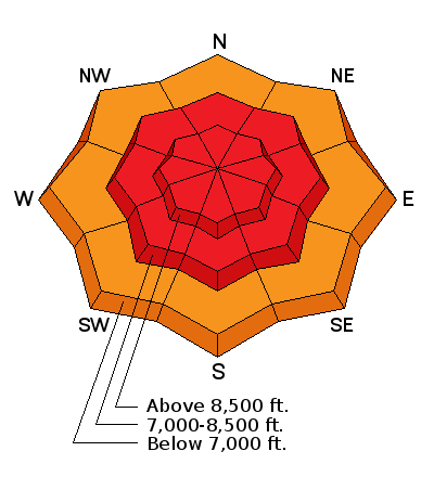
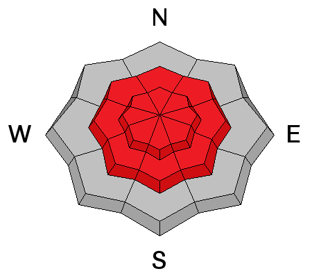
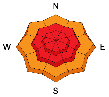
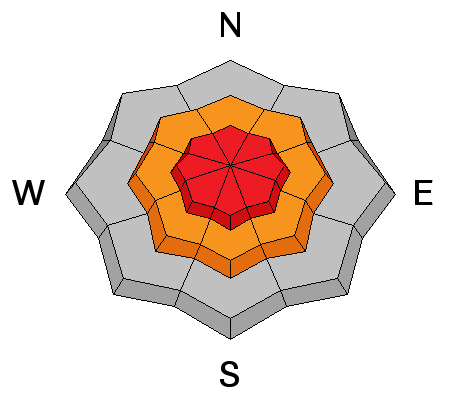
This information does not apply to developed ski areas or highways where avalanche control is normally done. This advisory is from the U.S.D.A. Forest Service, which is solely responsible for its content. This advisory describes general avalanche conditions and local variations always exist.