

Forecast for the Salt Lake Area Mountains

Thursday morning, April 14, 2016
The avalanche hazard is generally LOW, but may rise to MODERATE in the afternoon at the upper elevations with fresh wind drifts and sensitive storm snow. At lower and mid elevations, small loose wet slides are possible.
 Special Announcements
We will issue intermittent advisories through April as conditions warrant.
The next advisory will be posted on Friday April 15, 2016.
We will continue to post observations as they are especially important to the backcountry community this time of year. If you see anything you feel we should know about, please submit an observation.
 Weather and Snow
It is a soggy morning with 1-2" wet snow above 9500' and rain below. Winds are out of the southeast through southwest, blowing about 10 mph with gusts in the 20's mph at the mid and upper elevations. Temperatures are currently in the low 40's F at 8500' and low 30's at 10500'.
 Recent Avalanches
There were zero reports from the backcountry on Wednesday, and reports from resorts indicated wet snow at the surface would move with ski cuts.
Normal Caution

Description
For today, there are three things to watch for:
1. Rain on Snow. At low and mid elevations, warm temperatures and rain may have saturated the snowpack and small loose, wet slides are possible. I am not expecting this to be a widespread problem as we have been through several wet avalanche cycles this spring, and water can move freely through the snowpack at the lower and mid elevations. As colder temperatures arrive later today and tonight, this concern should diminish even further.
2. Storm Snow. Although we are not expecting large amounts of new snow, precipitation rates may increase later this morning and afternoon as a cold front passes. It is possible storm snow may become sensitive during periods of high precipitation rates.
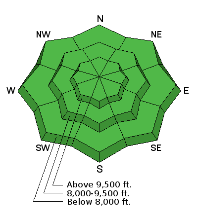
3. Wind Drifts. Watch for fresh wind drifts at the upper elevations. Although any fresh wind slabs will be found on mostly upper elevation north through east aspects, winds can move snow around terrain features and drift snow on all aspects at the upper elevations.
Both storm snow and wind drifted snow should only be a concern if snow amounts come in on the high end - or exceed - forecasted snow totals of 3-6", and ski cuts should be especially effective tool today for dealing with either of these concerns.
Additional Information
A cold front is approaching and should arrive in the Wasatch by late morning. Temperatures should drop from the high 30's F to low 30's F throughout the day as colder air moves into the region. Winds are forecasted to shift from the southwest to west to northwest after the front passes, and should blow in the teens with gusts in the 20's mph at mid elevations, and in the 20's mph with gusts in the 30's mph at upper elevations. Snowfall totals in the 3-6" range are expected. Isolated thunder is possible this afternoon. Colder temperatures overnight dropping into the low 20's F with continued snow showers.
General Announcements
|
GENERAL ANNOUNCEMENTS Remember your information can save lives. If you see anything we should know about, please help us out by submitting snow and avalanche conditions. You can also call us at 801-524-5304, email by clicking HERE, or include #utavy in your tweet or Instagram. To get help in an emergency (to request a rescue) in the Wasatch, call 911. Be prepared to give your GPS coordinates or the run name. Dispatchers have a copy of the Wasatch Backcountry Ski map. Backcountry Emergencies. It outlines your step-by-step method in the event of a winter backcountry incident. If you trigger an avalanche in the backcountry, but no one is hurt and you do not need assistance, please notify the nearest ski area dispatch to avoid a needless response by rescue teams. Thanks.
EMAIL ADVISORY If you would like to get the daily advisory by email you will need to subscribe here. DAWN PATROL Hotline updated daily by 5-530am - 888-999-4019 option 8. TWITTER Updates for your mobile phone - DETAILS UDOT canyon closures: LINK TO UDOT, or on Twitter, follow @UDOTavy, @CanyonAlerts or @AltaCentral Utah Avalanche Center mobile app - Get your advisory on your iPhone along with great navigation and rescue tools. Powderbird Helicopter Skiing - Blog/itinerary for the day Lost or Found something in the backcountry? - http://nolofo.com/ To those skinning uphill at resorts: it is critical to know the resort policy on uphill travel. You can see the uphill travel policy for each resort here. Benefit the Utah Avalanche Center when you shop from Backcountry.com or REI: Click this link for Backcountry.com or this link to REI, shop, and they will donate a percent of your purchase price to the UAC. Both offer free shipping (with some conditions) so this costs you nothing! Benefit the Utah Avalanche Center when you buy or sell on ebay - set the Utah Avalanche Center as a favorite non-profit in your ebay account here and click on ebay gives when you buy or sell. You can choose to have your seller fees donated to the UAC, which doesn't cost you a penny. This information does not apply to developed ski areas or highways where avalanche control is normally done. This advisory is from the U.S.D.A. Forest Service, which is solely responsible for its content. This advisory describes general avalanche conditions and local variations always exist. |