Forecast for the Abajo Area Mountains

Eric Trenbeath
Issued by Eric Trenbeath for
Sunday, April 10, 2016

At mid and lower elevations, the danger for loose wet, or even wet slab avalanches will rise to MODERATE today. Be alert to signs of wet instability within the snow pack as the day progresses. Watch for roller balls, pinwheels, and sloppy wet, or punchy snow, and stay off of and out from under steep slopes when these signs are present. There are also isolated areas where cornice fall poses a threat. Give them a wide berth if you are traveling on ridge crests where they are present.
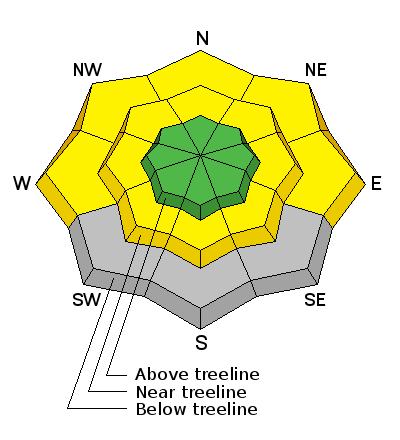
Low
Moderate
Considerable
High
Extreme
Learn how to read the forecast here
Special Announcements

This is our last weekend for scheduled advisories. Thanks to everyone who supported the program this season!

Weather and Snow

Skies are cloudy this morning, westerly ridge top winds are blowing in the 15-20 mph range, and temps range from 36 degrees at Buckboard Flat to 26 on Abajo Peak.

Winds, temperature and humidity on Abajo Peak.

Snow totals at Buckboard Flat.

Snow totals at Camp Jackson.

Avalanche Problem #1
Wet Snow
Type
Location
Likelihood
Size
Description

Mid and lower elevations did not undergo a solid refreeze last night, and temperatures at 10,000' will rise into the mid 40's today. Today you will need to be alert to signs of wet instability within the snow pack as the day progresses. Watch for roller balls, pinwheels, and sloppy wet, or punchy snow, and stay off of and out from under steep slopes when these signs are present. In areas where the snowpack is shallow and punchy, it may also be possible to trigger a wet slab avalanche.

Additional Information

A series of weak systems moving through the desert southwest will affect the area through the week.

Today

Scattered snow showers, mainly after 1pm. Some thunder is also possible. Mostly cloudy, with a high near 40. South southwest wind 5 to 10 mph. Chance of precipitation is 40%.

Tonight

A 50 percent chance of snow showers, mainly before midnight. Some thunder is also possible. Mostly cloudy, with a low around 30. Southwest wind around 10 mph becoming northwest after midnight. New snow accumulation of less than a half inch possible.

Monday

A 50 percent chance of snow showers, mainly after noon. Some thunder is also possible. Mostly cloudy, with a high near 40. West northwest wind 5 to 10 mph. New snow accumulation of 1 to 2 inches possible.

General Announcements

Let me know what you are seeing down there by posting an observation here. You can also call me on my cell phone at 801-647-8896

To receive this advisory by email go here.

This information does not apply to developed ski areas or highways where avalanche control is normally done. This advisory is from the U.S.D.A. Forest Service, which is solely responsible for its content. This advisory describes general avalanche conditions and local variations always exist.