Forecast for the Logan Area Mountains

Wednesday morning, April 6, 2016
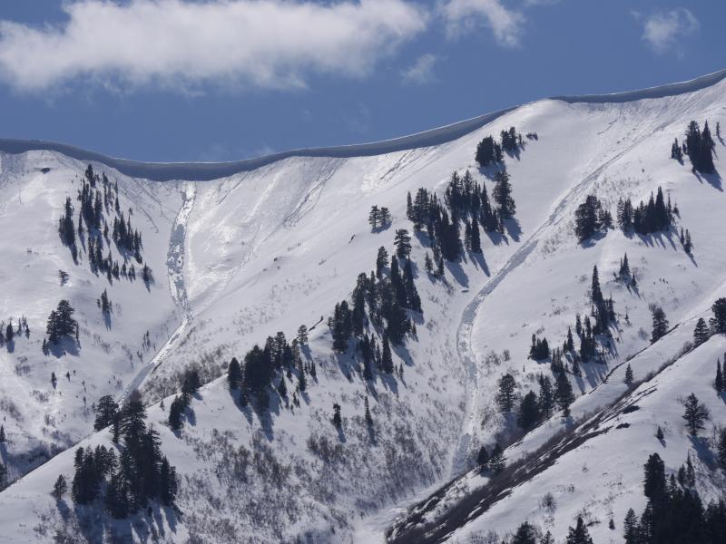
LOW (Level 1): Freezing overnight temperatures and westerly winds should keep the saturated snow fairly solid today in the backcountry. Heightened wet avalanche conditions may develop in some steep sheltered terrain as the surface snow warms and softens up again with daytime seasonal and solar warming. Use normal caution and retreat from steep slopes if you start sinking into melt-softened wet snow.

Weather and Snow
The Tony Grove Snotel at 8400' reports 30 degrees this morning and 87 inches of total snow containing 101% of average water for the date. Temperatures dropped below freezing again overnight and I'm reading 22 degrees at the 9700' CSI Logan Peak weather station, with west winds currently averaging around 25 mph. Looks like a decent refreeze of the wet snow surface at least at upper elevations. You might find areas with nice supportable and softening spring snow on sunny upper elevation slopes, but be willing to turn around if the wet snow you are in gets soft and sloppy.
Recent Avalanches
Natural wet avalanches during the heat of the day and involving late March snow were common across the Logan Zone in the first few days of April.
These long natural wet avalanches in the Wellsville Mountain Wilderness occurred during the weekend warm spell or on Monday (4-4-16)
***To view our updated list of backcountry observations and avalanche activity from around Utah, go to our observations page
Wet Snow


Description
Moist sluffs entraining melt-saturated surface snow are possible with warming daytime temperatures again today, most possible on sunny sheltered slopes where saturated surface snow becomes softened by solar warming. You should leave a steep slope if you start sinking into melt-softened wet snow.
Normal Caution


Description
You'll find stable snow conditions after mountain temperatures dipped below freezing overnight, solidifying the wet snow. Your biggest threat today could be falls or "slide for life" slides in steep terrain on hard refrozen snow.
Additional Information
HIGH PRESSURE ALOFT ACROSS THE GREAT BASIN WILL BRING DRY CONDITIONS AND A WARMING TREND FOR TODAY AND THURSDAY. A LOW PRESSURE SYSTEM OFF THE SOUTHERN CALIFORNIA COAST WILL SPREAD MOISTURE NORTH INTO UTAH LATE FRIDAY THROUGH THE WEEKEND.
Today: Sunny, with a high near 46. West northwest wind around 11 mph.
Tonight: Clear, with a low around 32. West wind 8 to 11 mph.
Thursday: Sunny, with a high near 56. North northwest wind 6 to 8 mph.
General Announcements
The National Avalanche Center recently completed an animated tutorial on the North American Avalanche Danger Scale. HERE
Please submit snow and avalanche observations from your ventures in the backcountry HERE. You can call us at 801-524-5304 or email HERE, or include #utavy in your Instagram or Tweet us @UAClogan. To report avalanche activity in the Logan Area or to contact the local avalanche forecaster call me, Toby, at 435-757-7578.
We'll update this advisory throughout the season on Monday, Wednesday, Friday, and Saturday mornings by about 7:30. This is the final week of regular advisories and we'll be issuing intermittent advisories as weather dictates starting next week (4-11-16)
This advisory is produced by the U.S.D.A. Forest Service, which is solely responsible for its content. It describes only general avalanche conditions and local variations always exist.