Forecast for the Moab Area Mountains

Eric Trenbeath
Issued by Eric Trenbeath for
Sunday, April 3, 2016

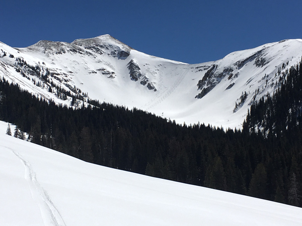
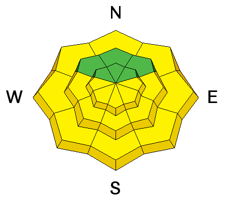
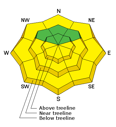
The avalanche danger is generally LOW this morning but will rise to MODERATE as daytime heating increases the potential for wet slide activity on steep, sun exposed slopes. Watch for signs of instability such as roller balls, pinwheels, and wet, sloppy snow, and get off of, and out from under steep slopes when these signs are present.

Remember that low danger doesn't mean no danger and unstable snow may exist on isolated terrain features, particularly in areas of more extreme radical terrain where it still may be possible to trigger and errant wind slab, or have a cornice break off beneath you. Continue to practice safe travel techniques and carry appropriate rescue gear.

Low
Moderate
Considerable
High
Extreme
Learn how to read the forecast here
Weather and Snow

Skies are clear, northerly ridge top winds are blowing in the 10-15 mph range, and temps are in the low 20's at 10,000'. Spring conditions are in effect, but good settled powder can still be found on northerly aspects. In our travels yesterday we observed people hitting big lines with impunity and it appears to be game on again in the La Sals.

Winds, temperature and humidity on Pre-Laurel Peak

New snow totals, temperature and humidity in Gold Basin

Total snow depth and temperature at Geyser Pass Trailhead

Ad
Avalanche Problem #1
Wet Snow
Type
Location
Likelihood
Size
Description

I've only observed very minor wet slide activity over the past few days. Nevertheless, with sunny skies and temperatures in the mid 40's at 10,000', you will need to be aware of the potential for wet slide activity on sun exposed slopes. Watch for the usual signs of instability such as roller balls, pinwheels, and off course, snow actually sluffing. And if you find yourself wallowing around in sloppy wet snow, it's time to get off of and out from under steep, sun exposed slopes.

Avalanche Problem #2
Normal Caution
Type
Location
Likelihood
Size
Description

Beyond the potential for wet slide activity in the afternoons, the snowpack is generally stable and the avalanche danger is mostly low. Low danger doesn't mean no danger, and areas of unstable snow may exist on isolated terrain features. As people push higher into more extreme terrain there still remains the possibility of triggering an errant wind slab. Cornices are also growing quite large and it's important to give them a wide berth. Continue to practice safe travel techniques by skiing or riding on slopes one at a time, and always carry a beacon, probe, and shovel.

Additional Information

High pressure will dominate the region through Monday. A weak disturbance to the north will bring some clouds and a slight chance of snow to the area on Tuesday. High pressure rebuilds for the remainder of the week with a stronger looking system out there on the horizon for next next weekend.

Today

Sunny, with a high near 44. West northwest wind around 10 mph.

Tonight

Mostly clear, with a low around 31. Northwest wind around 10 mph becoming west southwest after midnight.

Monday

Mostly sunny, with a high near 49. Southwest wind 10 to 15 mph.

Monday Night

A 10 percent chance of snow showers after midnight. Mostly cloudy, with a low around 29. Southwest wind around 15 mph.

Tuesday

A 20 percent chance of snow showers. Partly sunny, with a high near 41. Breezy, with a west northwest wind 15 to 20 mph.

Tuesday Night

Partly cloudy, with a low around 22.

Wednesday

Sunny, with a high near 42.

General Announcements

Road Conditions: The road is plowed down to the dirt and will get muddy in the afternoon.

Grooming Conditons: The road into Gold Basin has been packed out with roller and is suitable for cross country skiing. It's quite rough for skating.

To post an observation go here. You can view Moab observations here. You can also give me a call on my cell phone at 801-647-8896

To receive this advisory by email go here.

This information does not apply to developed ski areas or highways where avalanche control is normally done. This advisory is from the U.S.D.A. Forest Service, which is solely responsible for its content. This advisory describes general avalanche conditions and local variations always exist.