Forecast for the Skyline Area Mountains

Brett Kobernik
Issued by Brett Kobernik on
Sunday morning, March 20, 2016

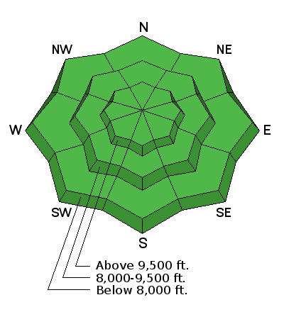
The overall avalanche danger is generally LOW today. Continue to follow safe protocols by only putting one person on a slope at a time. It's easy to let your guard down on LOW danger days so be prepared and consider what may happen if you trigger something in unforgiving terrain.

Low
Moderate
Considerable
High
Extreme
Learn how to read the forecast here
Weather and Snow

No big change in conditions from Saturday. Surface conditions are pretty firm in most spots with a little soft snow still on the protected north aspects. Up on the ridges, overnight low temperatures were in the mid 20s and the wind was fairly light from the west northwest.

Ad
Avalanche Problem #1
Normal Caution
Type
Location
Likelihood
Size
Description

It's about as "green light conditions" as we've seen yet this year. Keep in mind that LOW danger doesn't mean NO danger. If you hunt around, you can always find trouble. The steepest more east facing slopes that got wind loaded earlier this week would be most likely spots to trigger something.

Additional Information

We'll see slightly warmer temperatures today with ridgetop highs into the mid 40s. The wind should switch around more southerly and increase a bit late today. We're looking at some potential snow this week with the next storm moving through Tuesday into Wednesday with perhaps a secondary wave on Thursday. Weather models are hinting at another storm system for Saturday.

General Announcements

We will publish full detailed advisories Saturday and Sunday mornings by 7am. We will also be publishing basic avalanche danger ratings & info during the week.

If you are getting out into the mountains, we love to hear from you! You can SUBMIT OBSERVATIONS ONLINE or EMAIL US

If you would like to have avalanche advisories emailed to you, SIGN UP HERE

We can provide basic avalanche awareness presentations for your school, group or club. To enquire, CLICK HERE