


Forecast for the Skyline Area Mountains

Wednesday morning, March 16, 2016
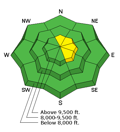
The majority of the terrain has a LOW avalanche danger. However, a MODERATE avalanche danger does exist on the steep upper elevation north through east facing terrain where recent fresh drifts may still be sensitive to a rider. Avoid obviously wind effected areas in the higher terrain. Human triggered avalanches are possible.
 Weather and Snow
The Manti Skyline picked 4 to 6 inches of snow in the higher terrain on Monday and an inch or two more overnight. The wind has been blowing quite a bit from the west northwest. Riders on Tuesday reported wind drifting. They did not find the new snow to be sensitive but they did not get into the higher bowls either. Those higher east facing bowls are where you would most likely find fresh drifts that may crack out on you.

Additional Information

General Announcements
We will publish full detailed advisories Saturday and Sunday mornings by 7am. We will also be publishing basic avalanche danger ratings & info during the week.
If you are getting out into the mountains, we love to hear from you! You can SUBMIT OBSERVATIONS ONLINE or EMAIL US
If you would like to have avalanche advisories emailed to you, SIGN UP HERE
We can provide basic avalanche awareness presentations for your school, group or club. To enquire, CLICK HERE