

Forecast for the Uintas Area Mountains

Friday morning, March 11, 2016
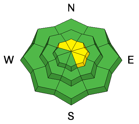
Pockets of MODERATE avalanche danger exist and human triggered avalanches are possible, especially on steep, wind drifted slopes and particularly in terrain with a thin, weak snowpack. While it's becoming more the exception than the rule, any avalanche that fails on weak, sugary snow near the ground, has the potential to break deeper and wider than you might expect.
In addition, while generally LOW this morning the danger of wet avalanche activity rises to MODERATE on steep, sun exposed slopes and human triggered avalanches are possible as the day heats up. Avoidance is easy... simply get off of and out from under steep sunny slopes during the heat of the day.
 Weather and Snow
High, thin clouds filtered into the region late yesterday, but cleared out early this morning, allowing the snowpack to cool somewhat. It's balmy though, with most mid and upper elevations reporting temperatures in the upper 20's and mid 30's. Southerly winds ramped up around 9:00 last night and are blowing 30-50 mph along the high peaks. Snow surface conditions run the gamut of supportable and unsupportable crusts. I think you'll find a short-lived window of corn on low and mid elevation south aspects with shallow powder still lingering on high elevation north facing slopes. Everything in-between offers character building potential.
Uinta weather station network info is found here.
Trip reports and observations are found here.
 Recent Avalanches

Wind Drifted Snow
Description
While mostly well-behaved and predictable, today you'll find a few lingering drifts on steep, leeward, upper elevation slopes. In general these are manageable, easy to detect, and easier to avoid. However, if you're getting after it and your travels take you into the wind zone, look for and avoid any fat, rounded piece of snow, especially if it feels or sounds hollow like a drum.
In addition to fresh drifts, a rogue slab breaking into weak snow near the ground isn't out of the question and our usual suspects come to mind... steep, rocky terrain with a shallow, weak snowpack. Any slide that breaks to weak snow near the ground has the potential to quickly ruin your day.
Wet Snow

Description
The sun is high in the sky and all aspects and elevations are feeling the heat. While I might welcome the suns intense rays on my skin, the snowpack feels differently. Wet avalanche activity will increase on all steep slopes as the day heats up, but fortunately there's little mystery to avoiding this avalanche dragon. Simply get off of and out from under steep sunny slopes and avoid terrain traps like road cuts and gullies, especially as the snow surface gets damp and manky.
Additional Information
Mostly sunny skies and a warm southerly flow continues over the area today with high temperatures reaching into the mid 50's. Southwest winds increase through the afternoon, gusting into the 60's by days end. Overnight lows barely reach freezing and a weakening system brings a chance of rain and snow along with slightly cooler temperatures to the region on Saturday. Unsettled and cooler weather Sunday opens the door to a stronger storm slated to arrive Monday.
General Announcements
Remember your information can save lives. If you see anything we should know about, please participate in the creation of our own community avalanche advisory by submitting snow and avalanche conditions. You can call me directly at 801-231-2170, email [email protected], or email by clicking HERE If Craig is unavailable you can reach his partner Trent at 801-455-7239, email [email protected]
This is a great time of year to schedule a free avalanche awareness presentation for your group or club. You can contact me at 801-231-2170 or email [email protected]. To register for the first in our series of on-the-snow sled specific classes you can register here.
The information in this advisory is from the US Forest Service which is solely responsible for its content. This advisory describes general avalanche conditions and local variations always occur.
The information in this advisory expires 24 hours after the date and time posted, but will be updated by 7:00 AM on Saturday, March 12th.