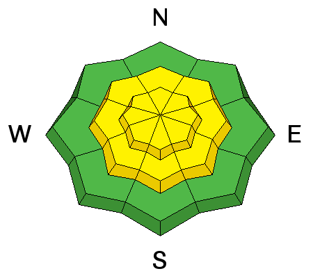
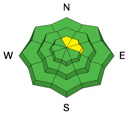
Forecast for the Skyline Area Mountains

Brett Kobernik
Issued by Brett Kobernik for
Sunday, March 6, 2016

The avalanche danger will be increasing today and overall will reach MODERATE as the snow and wind do their thing. Watch for cracking within the new snow which indicates it is sensitive. The chance for triggering a deep slab avalanche on the higher north through east facing steep slopes will be increasing later today as the new snow adds weight.
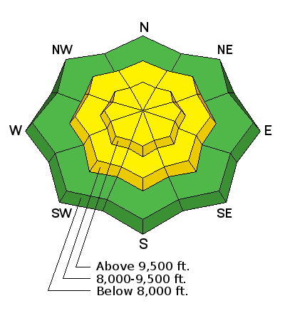
Low
Moderate
Considerable
High
Extreme
Learn how to read the forecast here
Weather and Snow

A storm is on our door step and we've seen just a little precipitation already this morning. Temperatures are mild with ridgetop readings in the low 30s and southwest wind in the light to moderate speed category.

Below is a video that I put together on Saturday that sums up snow and weather over the last month and what to expect with this storm.

20160305-Roundup from Brett Kobernik on Vimeo.

Ad
Avalanche Problem #1
New Snow
Type
Location
Likelihood
Size
Description

You will want to pay attention to how the new snow is behaving as it stacks up today. I'm guessing that it will be fairly well behaved but keep in mind that that avalanche danger will be increasing with additional snow and wind today. Watch for cracking within the new snow. Sidehill or ski cut small test slopes to see if the new snow is sensitive.

Avalanche Problem #2
Persistent Weak Layer
Type
Location
Likelihood
Size
Description

The big question is whether the new snow will add enough weight to make the old weak snow near the ground active again? We don't know for sure, therefore, you must anticipate the chance for larger avalanches breaking to the ground in the upper elevation north through east facing slopes which have already avalanched earlier this season. It is possible that enough settlement occurred with all the warm weather we've had to heal these weak layers. However, they are still down there and could become reactive. We probably won't see enough weight today from the new snow but perhaps by Monday there may be enough.

Additional Information

Today's storm is going to start out warm and we should see 2 to 4 inches of snow. Southwest wind should increase into the strong category by the afternoon. Rain/snow levels will be at least 8000 feet and will lower as temperatures fall this afternoon. A cold front will move through this afternoon and should produce a period of heavier snowfall. We should see another 3 to 6 inches of snow late today and tonight. Wind will shift to the northwest and decrease some in speed.

General Announcements

We will publish full detailed advisories Saturday and Sunday mornings by 7am. We will also be publishing basic avalanche danger ratings & info during the week.

If you are getting out into the mountains, we love to hear from you! You can SUBMIT OBSERVATIONS ONLINE or EMAIL US

If you would like to have avalanche advisories emailed to you, SIGN UP HERE

We can provide basic avalanche awareness presentations for your school, group or club. To enquire, CLICK HERE