Forecast for the Moab Area Mountains

Eric Trenbeath
Issued by Eric Trenbeath for
Saturday, February 27, 2016

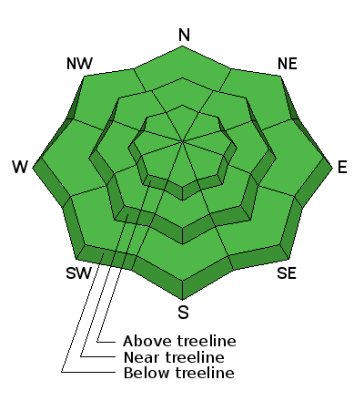
The avalanche danger is generally LOW but remember that low danger doesn't mean no danger. Continue to exercise caution in areas of steep, rocky, more radical terrain where you may still be able to trigger an isolated wind slab, or even a deeper, buried persistent slab.

As the day heats up, be alert to signs of wet instability on sun exposed slopes such as roller balls, pinwheels, or sloppy wet snow. Stay off of and out from under steep slopes when these signs are present.

Low
Moderate
Considerable
High
Extreme
Learn how to read the forecast here
Weather and Snow

Well it may not be winter, but at least it's beautiful in the mountains. Conditions are spring like with a mix of wind and sun crusts, and some sloppy snow in the afternoon, but Monday's 6" of new snow has freshened up the scene and made for some decent dust on crust conditions on sheltered, northerly aspects. Supportable corn-like snow is developing on sheltered, mid elevation, sun exposed slopes.

Winds have seen a slight increaes overnight shifting from WNW to WSW and are averaging 15-20 mph. It's 26 degrees on Pre Laurel Peak, and 34 at the Geyser Pass Trailhead.

Base Depth in Gold Basin: 64"

Pretty decent dust on crust conditions exist on upper elevation, northerly aspects. Lower angle slopes provide the most cushion.

Winds, temperature and humidity on Pre-Laurel Peak

New snow totals, temperature and humidity in Gold Basin

Total snow depth and temperature at Geyser Pass Trailhead

Ad
Avalanche Problem #1
Normal Caution
Type
Location
Likelihood
Size
Description

The avalanche danger is generally low right now, but low danger doesn't mean no danger and you should always maintain avalanche awareness and practice safe travel techniques in avalanche terrain. Here are a few problems to remain on the lookout for:

Wind Slabs: You may still encounter isolated wind slab pockets in areas of steep, radical, wind exposed terrain. Suspect the lee sides of terrain features such as gully walls, sub ridges, or rock buttresses.

Persistent / Deep Slabs: There still may be isolated pockets where a hard slab sits on top of weak, shallow, sugary snow. Suspect areas of rocky, radical terrain that has avalanched or been repeatedly scoured out through the season. Give extra caution to steep rollovers and blind break overs.

Loose Wet Slides: As the day heats up be alert to signs of wet instability such as rollerballs or pinwheels, and stay off of and out form under steep slopes when these signs are present.

Additional Information

A weak storm system to the north will stream high clouds over our area today. A "stronger" weak storm to the north will bring a few clouds and chance for light snow on Monday but don't hold your breath.

Today

Mostly sunny, with a high near 37. Breezy, with a west southwest wind 15 to 25 mph.

Tonight

Partly cloudy, with a low around 25. Breezy, with a northwest wind 15 to 25 mph.

Sunday

Sunny, with a high near 32. Northwest wind 10 to 15 mph.

Sunday Night

A 20 percent chance of snow after 11pm. Partly cloudy, with a low around 23. West wind 10 to 15 mph.

Monday

A 40 percent chance of snow. Partly sunny, with a high near 33. Breezy, with a west northwest wind 15 to 20 mph, with gusts as high as 35 mph.

General Announcements

Road Conditions: The new snow has been packed in and in some places has already melted off down to the dirt.

Grooming: All trails were groomed on Friday.

To post an observation go here. You can view Moab observations here. You can also give me a call on my cell phone at 801-647-8896

To receive this advisory by email go here.

This information does not apply to developed ski areas or highways where avalanche control is normally done. This advisory is from the U.S.D.A. Forest Service, which is solely responsible for its content. This advisory describes general avalanche conditions and local variations always exist.