

Forecast for the Skyline Area Mountains

Monday morning, February 22, 2016
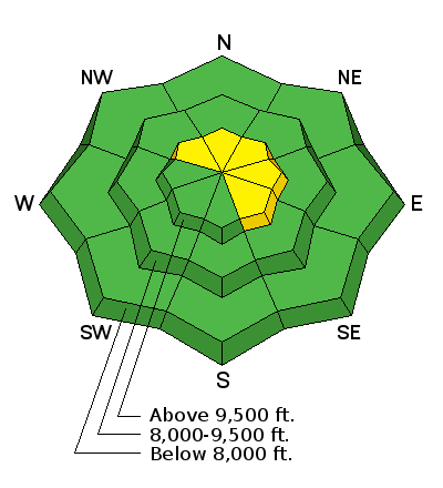
Despite not much snow available on the surface for transporting due to sun crusts, the wind always seems to find a way to drift snow. Northwest wind speeds will increase during the day today which will also increase the avalanche danger slightly. A MODERATE danger still exists in the high north through east facing steep slopes which have already avalanched earlier this season and are now filled back in. Avalanches breaking to the ground are still a concern. You may find some other scattered shallow wind drifts along the higher ridgelines on northwest through southeast facing slopes.

Additional Information

General Announcements
We will publish full detailed advisories Saturday and Sunday mornings by 7am. We will also be publishing basic avalanche danger ratings & info during the week.
If you are getting out into the mountains, we love to hear from you! You can SUBMIT OBSERVATIONS ONLINE or EMAIL US
If you would like to have avalanche advisories emailed to you, SIGN UP HERE
We can provide basic avalanche awareness presentations for your school, group or club. To enquire, CLICK HERE